

Aerial Photography and Maps of Abandoned Airports
Aerial Photographs of Abandoned Airports for Immediate Download
|
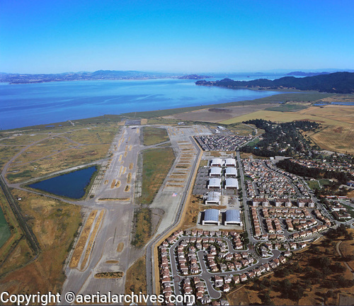
Among the abandoned airports in the Aerial Archives collection are Bal Buena airport in Mexico City, Crissy Field in San Francisco, the Alameda Naval air station in Alameda, California, Denver Stapleton, Hamilton Field, in Marin County, California and the Cotati airport in Sonoma County, California. The aerial photograph of residential development at the abandoned Hamilton Field airport, Novato, CA shown above is available for immediate online license or prints or, to obtain it optimized to your needs please contact Aerial Archives directly and reference the ID number in the caption to the photograph. Additional aerial photograph of development at the abandoned Hamilton Field airport, in Novato, CA are available at Hamilton Field aerial photographs or, to obtain it optimized to your needs please contact Aerial Archives directly and reference the ID number in the caption to the photograph.
|
|
Aerial Archives also provides aerial maps and satellite photography of abandoned airports around the world.
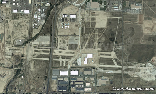
The aerial map of the abandoned Stapleton airport in Denver, Colorado shown above is available for immediate online license or prints or, to obtain it optimized to your needs please contact Aerial Archives directly and reference the ID number in the caption to the photograph. For current aerial photography coverage of abandoned airports please contact us. For historical research of aerial photography and aerial maps of abandoned airports, California we recommend that you use the research request form. Additional information about the process of researching historical aerial photography for your location is available at aerial photography research. |