

San Mateo County Aerial Photography For Immediate Download
|
Aerial Archives creates custom aerial photography of San Mateo county, California and its library contains an extensive selection of aerial photographs of San Mateo, California. This includes oblique aerial photographs of all of San Mateo county including aerial views of each of the individual cities and townships of San Mateo county and San Mateo county's Pacific coastline. Among the aerial photographs included in this collection of aerial photography are aerials of: Brisbane, Burlingame, Daly City, the Crystal Springs reservoir, Foster City, Half Moon bay, Hillsborough, Millbrae, Pacifica, Redwood Shores, Redwood City, the San Andreas fault, San Carlos, San Mateo, South San Francisco, San Bruno mountain and Woodside.The archive also contains a comprehensive collection of vertical (straight down) aerial photography of San Mateo county including aerial photos of San Mateo County both in color and black and white. Additional information is available at aerial maps of San Mateo County.
|
|
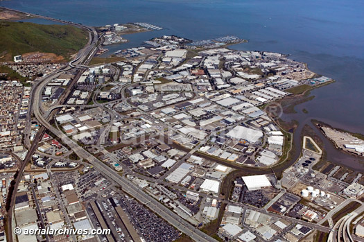
The aerial photograph of the the biotechnology center at Oyster Point in South San Francisco, CA shown above is available for immediate online license or prints, or to obtain this image optimized to your specification, please contact Aerial Archives directly.
For custom aerial photography of a location in San Mateo county or for current aerial photography coverage of San Mateo County, California please contact us. For historical research of aerial photography of San Mateo County, California we recommend that you use the research request form. Additional information about the process of researching historical aerial photography for your location is available at aerial photography research.
|