
Historical Aerial Photography of Las Vegas, Nevada
Aerial Photographs of Las Vegas for Immediate Download

Historical Aerial Photography Comparison
Showing Changes to Las Vegas
Clark County, Nevada
1973 and 2010
Image ID: AHLV3391
© aerialarchives.com
Terms of Image Use |
Immediate License or Prints
Feedback
|
An extensive selection of high resolution historical aerial photography of Las Vegas and Clark county Nevada is available from Aerial Archives. The change over even brief periods of time is particularly dramatic in Las Vegas and aerial photography is a great way to show that change. To view additional aerial photographs of Las Vegas available for immmediate license or prints, please visit Las Vegas Aerial Photography.
Historical aerial photographs are available for advertising and editorial use as well as for use to establish facts about historical conditions by law firms, investigators, and researchers conducting due diligence.
Aerial Archives also provides current aerial photographs which can be used to make a then and now comparision with the historical aerial photography.
The aerial photographs of the comparison in real estate developmment between 1973 and 2010 in Las Vegas shown on this page is available for immediate online license or, to obtain it optimized to your needs please contact Aerial Archives
directly and reference the ID number in the caption to the photograph.
More detailed views of the historical and current aerial perspectives are shown below.
|
Historical Aerial Photography of McCarran Airport Las Vegas, Nevada
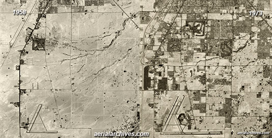
Historical Aerial Photography Comparision
Showing Change to Las Vegas
Around the McCarran Airport
Clark County, Nevada
1958 and 1973
Image ID: AHLV3392
© aerialarchives.com
Terms of Image Use |
Feedback
|
The changes around the McCarran Airport from 1958 to 1973 were dramatic as the two images above show. Even more dramatic are the changes that took place in the western portion of the city decades later.
To obtain the historical and current aerial photography comparision of Las Vegas, Nevada shown above please contact Aerial Archives
directly and reference the ID number in the caption to the photograph.
|
Historical Aerial Photography of Summerlin, Las Vegas, Nevada
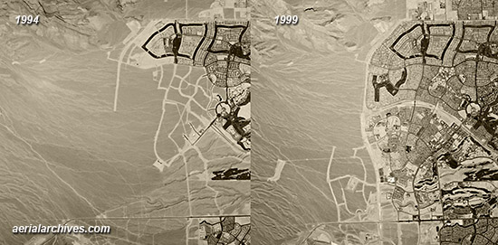
Historical Aerial Photography Comparison
Showing Dramatic Residential Development
Summerlin, Las Vegas
Clark County, Nevada
1994 and 1999
Image ID: AHLV3393
© aerialarchives.com
Terms of Image Use |
Immediate License or Prints
Feedback
|
Residential development was rapid during the 1990s in Las Vegas as the two historical aerial photographs of Summerlin show. A comparision to the Summerlin of today shows that development continued through the residential real estate boom years.
The aerial photographs of the comparision in real estate developmment between 1994 and 1999 in Las Vegas shown on this page is available for immediate online license or prints or, to obtain it optimized to your needs please contact Aerial Archives
directly and reference the ID number in the caption to the photograph.
|
Historical Aerial Photography of McCarran Airport Las Vegas, Nevada 1950s
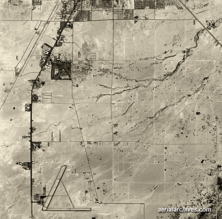
Historical Aerial Photograph of
McCarran Airport
Las Vegas, Clark County, Nevada
1958
Image ID: AHLV3389
© aerialarchives.com
Terms of Image Use |
Immediate License or Prints
Feedback
|
A more detailed view of the amount of open space around McCarran Airport in 1958.
The historical aerial photograph of McCarran Airport, Las Vegas, Nevada shown above is available for immediate online license or prints or, to obtain it optimized to your needs please contact Aerial Archives
directly and reference the ID number in the caption to the photograph.
|
Historical Aerial Photography of Las Vegas 1973
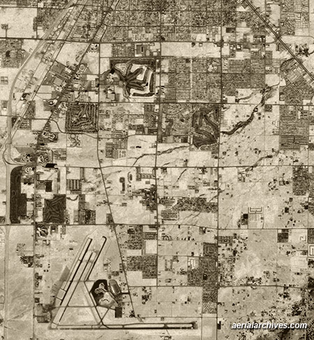
Historical Aerial Photograph of
McCarran Airport
Las Vegas, Clark County, Nevada
1973
(Compare with Identical View Above from 1958)
Image ID: AHLV3387
© aerialarchives.com
Terms of Image Use |
Immediate License or Prints
Feedback
|
A more detailed view of what McCarran Airport and its surroundings looked like in 1973.
The historical aerial photograph of McCarran Airport, Las Vegas, Nevada shown above please is available for immediate license or prints or for customized service please contact Aerial Archives directly and reference the ID number in the caption to the photograph..
|
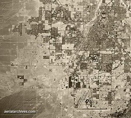
Historical Aerial Photograph of
Las Vegas, Clark County, Nevada
1973
(Compare with Identical View Below from 2010)
Image ID: AHLV3387
© aerialarchives.com
Terms of Image Use |
Immediate License or Prints
Feedback
|
This broader view of Las Vegas in 1973 provides a perspective on the changes that have taken place from 1973 through 2010.
The historical aerial photograph of Las Vegas, Nevada shown above please is available for immediate license or prints or for customized service please contact Aerial Archives directly and reference the ID number in the caption to the photograph.
|
Current Aerial Photography of Las Vegas
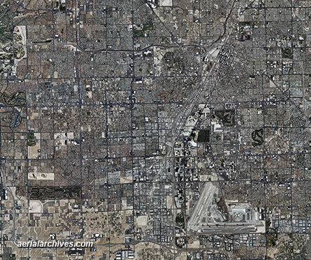
Aerial Photograph of
Las Vegas, Clark County, Nevada
2010
Image ID: AHLV3390
© aerialarchives.com
Terms of Image Use |
Immediate License or Prints
Feedback
|
An extensive selection of high resolution vertical aerial photography (aerial photo maps) of Las Vegas and Clark county Nevada is available from Aerial Archives. For additional information, please consult aerial photo maps of Las Vegas.
Aerial Archives provides research services for historical aerial photographs and can usually locate an useful historical aerial photograph for clients.
For historical research of aerial photography of Las Vegas, we recommend that you use the pdf research request form. Additional information about the process of researching historical aerial photography for your location is available at aerial
photography research.
Copyright by Aerial Archives
|
