
Historical Aerial Photography | Then and Now Comparisons
Historical Aerial Photograph of
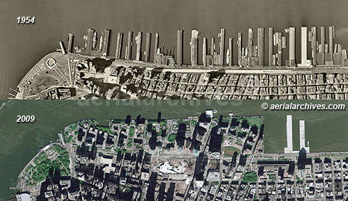
Piers at the Hudson River Waterfront
Comparison of Changes in 55 Years
Manhattan, New York City
1954 and 2009
Image ID: AHLV3409
© aerialarchives.com
Terms of Image Use | Immediate License or Print
Immediate License or Print, 1954 | Immediate License or Print, 2009
Comment in Blog
|
Placing aerial photographs from different eras next to each other is a great way to visualize change over time. This series of historical and current aerial photographs of United States cities shows some of the changes that have taken place during a number of decades.
The Hudson river shoreline of Manhattan, for example, changed dramatically during the last five decades. The two historical aerial photographs illustrate the amount of change that has occurred at this portion of Manhattan between 1954 and 2009. The piers along the Hudson river were still actively used in 1954. Piers 1 through 21 were buried under landfill from the World Trade Center construction project and became Battery Park City.
The historical aerial photographs of the Hudson River waterfront in New York City shown above are available for immediate online license or prints or, to obtain them optimized to your needs please contact Aerial Archives
directly and reference the ID number in the caption to the photograph. The historical aerial photographs can also be obtained individually. For immediate download, please use the links under the image caption.
For more infomation about historical aerial photography of New York City, please visit historic aerial photography of New York. Additional details about current vertical (straight down) aerial photography of New York City are available at aerial maps of New York. Information about current oblique (at an angle) aerial photography of New York City are available at aerial maps of New York.
If we don't already have an aerial then and now comparison view of your city or years of interest, we can create one for you.
|
Historical Aerial Photography | Then and Now Comparisons | Las Vegas

Historical Aerial Photography Comparison
Showing Changes to Las Vegas
Clark County, Nevada
1973 and 2010
Image ID: AHLV3391
© aerialarchives.com
Terms of Image Use |
Immediate License or Prints
Comment in Blog
|
Las Vegas has undergone dramatic change in very short periods of time.
The historical aerial photographs of the comparison in real estate developmment between 1973 and 2010 in Las Vegas shown on this page are available for immediate online license or prints or, to obtain them optimized to your needs please contact Aerial Archives
directly and reference the ID number in the caption to the photograph.
For more infomation about historical aerial photography of Las Vegas, please visit historic aerial photography of Las Vegas. Additional details about current aerial photography of Las Vegas are available at aerial maps of Las Vegas.
|
Historical Aerial Photography of Miami, Florida
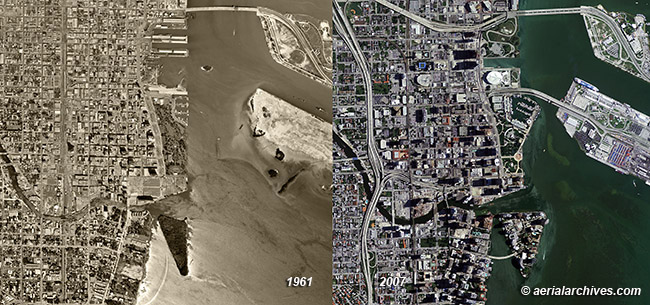
Historical Aerial Photography Comparison
Showing Changes During 46 Years
Miami, Florida
1961 and 2007
Image ID: AHLV3404
© aerialarchives.com
Terms of Image Use |
Immediate License or Prints
Feedback
|
There have been dramatic changes to Miami and many other portions of Florida during the last several decades. The two historical aerial photographs show how much the downtown area of Miami has changed and how the port has developed.
The historical aerial photographs of the comparison of development between 1961 and 2007 in Miami, Florida shown above are available for immediate online license or prints or, to obtain them optimized to your needs please contact Aerial Archives
directly and reference the ID number in the caption to the photograph.
For more infomation about historical aerial photography of Miami, please visit historic aerial photography of Miami. Additional details about current aerial photography of Miami are available at aerial photography of Miami.
|
Historical Aerial Photography | Then and Now Comparisons | San Diego
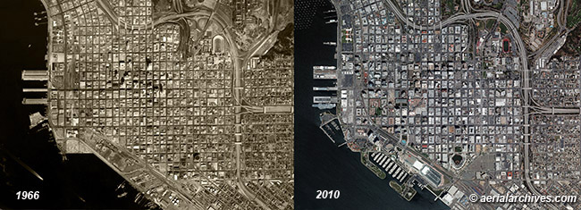
Historical Aerial Photography Comparison
Showing Changes During Four Decades
San Diego, California
1966 and 2010
Image ID: AHLV3398
© aerialarchives.com
Terms of Image Use |
Immediate License or Prints
Feedback
|
The historical aerial photographs of the comparison of developmment between 1966 and 2010 in San Diego, California shown above are available for immediate online license or prints or, to obtain them optimized to your needs please contact Aerial Archives
directly and reference the ID number in the caption to the photograph.
For more infomation about historical aerial photography of San Diego, California, please visit historic aerial photography of San Diego. Additional details about current aerial photography of San Diego are available at aerial photography of San Diego.
|
Historical Aerial Photography | Then and Now Comparisons | Philadelphia
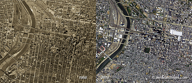
Historical Aerial Photography Comparison
Showing Changes During 60 Years
Philadelphia, Pennsylvania
1950 and 2010
Image ID: AHLV3413
© aerialarchives.com
Terms of Image Use |
Immediate License or Prints
Feedback
|
The historical aerial photographs of the comparison between 1950 and 2010 in Philadelphia shown on this page are available for immediate online license or prints or, to obtain them optimized to your needs please contact Aerial Archives
directly and reference the ID number in the caption to the photograph.
Additional details about current aerial photography of Philadelphia, Pennsylvania are available at aerial photography of Philadelphia.
|
Historical Aerial Photography | Then and Now Comparisons | Pittsburgh, Pennsylvania
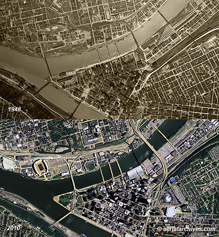
Historical Aerial Photography Comparison
Showing Changes During 62 Years
Pittsburgh, Pennsylvania
1948 and 2010
Image ID: AHLV3412
© aerialarchives.com
Terms of Image Use |
Immediate License or Prints
Feedback
|
The historical aerial photographs of the comparison between 1948 and 2010 in Pittsburgh, Pennsylvania shown on this page are available for immediate online license or prints or, to obtain them optimized to your needs please contact Aerial Archives
directly and reference the ID number in the caption to the photograph.
|
Historical Aerial Photography | Then and Now Comparisons | New Orleans, Louisiana
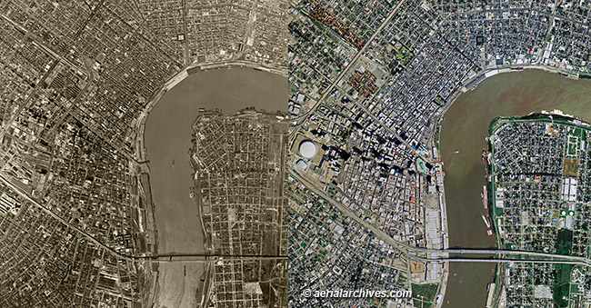
Historical Aerial Photography Comparison
Showing Changes During 33 Years
New Orleans, Louisiana
1964 and 2007
Image ID: AHLV3414
© aerialarchives.com
Terms of Image Use |
Immediate License or Prints
Feedback
|
The historical aerial photographs of the comparison between 1967 and 2010 in New Orleans, Louisiana shown on this page are available for immediate online license or prints or, to obtain them optimized to your needs please contact Aerial Archives
directly and reference the ID number in the caption to the photograph.
Additional details about aerial photography of New Orleans, Louisiana are available at aerial photography of New Orleans.
For custom then and now comparisons or for current or historical aerial photography not shown on this site, please contact us.
Copyright by Aerial Archives
|
