
Historical Aerial Photographs of New York
New York Historical Aerial Photographs For Immediate Download
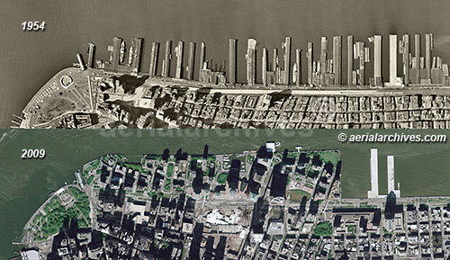
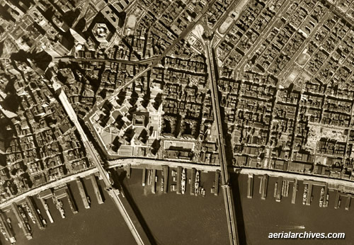
Historical Aerial Photograph of
Piers at the Hudson River Waterfront
Comparison of Changes in 55 Years
New York City
1954 and 2009
Image ID: AHLV3409
© aerialarchives.com
Terms of Image Use | Immediate License or Print
Immediate License or Print, 1954 | Immediate License or Print, 2009
Feedback
|
An extensive selection of high resolution historical aerial photography of New York is available from Aerial Archives. Historical aerial photographs are available for advertising and editorial use as well as for use to establish facts about historical conditions by law firms, investigators, and researchers conducting due diligence. Aerial Archives also provides current aerial photographs which can be used to make a then and now comparision with the historical aerial photography. Additional details about current aerial photography of New York City are available at aerial maps of New York.
Aerial Archives also provides research services for historical aerial photographs where they do
not exist in the archive, and can usually locate a useful historical aerial photograph for clients.
For historical research of aerial photography of New York City or other portions of New York State we recommend that you use the pdf research request form. Additional information about the process of researching historical aerial photography for your location is available at aerial
photography research.
The historical aerial photographs of the Hudson River waterfront in New York City shown above are available for immediate online license or, to obtain them optimized to your needs please contact Aerial Archives
directly and reference the ID number in the caption to the photograph. The historical 1953 and 2009 aerial photographs can also be obtained individually. For immediate download, please use the links under the image caption.
|
Historical Aerial Photographs of the New York Waterfront
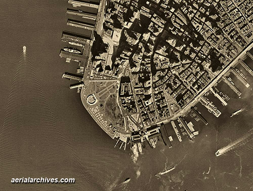
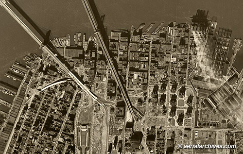
Historical Aerial Photograph of
Battery Park, Downtown Manhattan
New York City
1954
Image ID: AHLV3267
© aerialarchives.com
Terms of Image Use |
Immediate License or Prints
Feedback
|
The New York City waterfront has undergone dramatic changes over time. Historical aerial photographs of New York City are a great way to document these changes.
To obtain the historical aerial photograph of the Hudson River waterfront in New York City shown above is available for immediate online license or prints or, to obtain a large mural or a file optimized to your needs please contact Aerial Archives
directly and reference the ID number in the caption to the photograph.
|
Historical Aerial Photographs of Midtown Manhattan
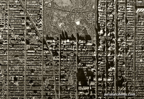
Historical Aerial Photograph of
Central Park and Midtown Manhattan
New York City
1954
Image ID: AHLV3271
© aerialarchives.com
Terms of Image Use |
Immediate License or Prints
Feedback
|
Midtown Manhattan has also undergone continuous changes over time. Historical aerial photographs of New York City document the progression of real estate development in Manhattan over the course of numerous decades.
The historical aerial photograph of the East River waterfront in New York City shown above is available for immediate online license or prints or, to obtain a mural or a digital file optimized to your needs please contact Aerial Archives
directly and reference the ID number in the caption to the photograph.
|
Historical Aerial Photographs of Environmental Issues New York City
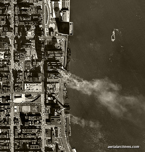
Historical Aerial Photograph of
United Nations Headquarters (top) just after completion (1952) and
Smoke Being Released from Several Chimneys
East River Waterfront
New York City
1954
Image ID: AHLV3273
© aerialarchives.com
Terms of Image Use |
Immediate License or Prints
Feedback
|
Historical aerial photographs of New York City also illustrate changing environmental issues, including air and water pollution.
The historical aerial photograph of the East River waterfront in New York City shown above is available for immediate online license or prints or, to obtain a mural or a digital file optimized to your needs please contact Aerial Archives
directly and reference the ID number in the caption to the photograph.
|
Historical Aerial Photographs of East River Waterfront New York City
Historical Aerial Photograph of
East River Waterfront
at Brooklyn and Williamsburg Bridges
New York City
1954
Image ID: AHLV3307
© aerialarchives.com
Terms of Image Use |
Immediate License or Prints
Feedback
|
The historical aerial photograph of the Brooklyn East River waterfront in New York City shown above is available for immediate online license or prints or, to obtain a mural or a digital file optimized to your needs please contact Aerial Archives
directly and reference the ID number in the caption to the photograph.
|
Historical Aerial Photographs of Brooklyn, New York
Historical Aerial Photograph of
Brooklyn Heights
at Brooklyn and Williamsburg Bridges
New York City
1954
Image ID: AHLV3305
© aerialarchives.com
Terms of Image Use |
Immediate License or Prints
Feedback
|
Historical aerial photography is available for the entire borough of Brooklyn.
The historical aerial photograph of the Brooklyn Heights in New York City shown above is available for immediate online license or prints or, to obtain a mural or a digital file optimized to your needs please contact Aerial Archives
directly and reference the ID number in the caption to the photograph.
|
Historical Aerial Photographs of New York Airports
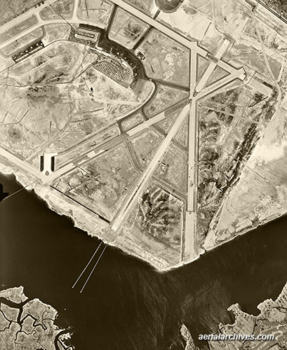
Historical Aerial Photograph of
John F. Kennedy International Airport
while it was still known Anderson Field
and by its original name, Idlewild Airport
Queens County, Long Island, New York City
1954
Image ID: AHLV3309
© aerialarchives.com
Terms of Image Use |
Immediate License or Prints
Feedback
|
High resolution historical aerial photographs are available for all New York airports, including LaGuardia Airport and it's Marine Air Terminal, Newark International airport, Teterborough airport, Long Island MacArthur airport in Islip, Floyd Bennett Field in Brooklyn (closed in 1971)and Westchester County airport.
The historical aerial photograph of the John F. Kennedy International Airport shown above is available for immediate online license or prints or, to obtain a large mural or specially prepared digital file optimized to your needs please contact Aerial Archives
directly and reference the ID number in the caption to the photograph.
|
Historical Oblique Aerial Photography of New York City

Historical aerial photograph Midtown Manhattan
including the Empire State building,
New York City with the Hudson River and piers in the foreground
2004
Image ID: AHLB2136
© Herb Lingl/aerialarchives.com
Terms of Image Use |
Immediate License or Print
Additional aerial photos of midtown Manhattan for Immediate License
|
The historical oblique aerial photograph shown above of midtown Manhattan, New York City as viewed from the Hudson River is available for immediate online license or prints or, to obtain it optimized to your needs please contact Aerial Archives directly and reference the ID number in the caption to the photograph.
Historical aerials are also available for any other portion of New York City, including each of the five boroughs, as well as any other portion of the United States.
For current vertical (straight down) aerial photography of New York, please consult Aerial Maps of New York. For current oblique (at an angle) aerial photography of New York, please consult Aerial Photographs of New York.
|
Copyright by Aerial Archives
