

Aerial Photography, Satellite Imagery and Remote Sensing Data
for Litigation and Other Legal Applications
|
Aerial Archives services include comprehensive litigation support services and evidence acquisition for legal matters. Aerial Archives shoots assignments to support specific legal cases or negotiations and provides research services to assist clients in locating high resolution aerial and satellite imagery. If useful to the early stages of a potential litigation, Aerial Archives will help a client create a customized aerial, and if required, satellite surveillance program. The firm also provides comprehensive assistance with aerial imagery interpretation and supporting documentation for lawyers, paralegals and investigators, and if requested, will oversee the production of presentation graphics for trials and hearings. Many legal cases benefit from aerial photography, satellite imagery or remote sensing evidence. Attorneys have used aerial photography and satellite imagery that Aerial Archives provided in environmental litigation, property boundary and easement litigation, accident cases, land management cases, criminal cases and numerous other applications. Aerial photography and satellite imagery are also highly probative evidence for documenting changes over time.
|
Aerial Photography and Satellite Imagery
|
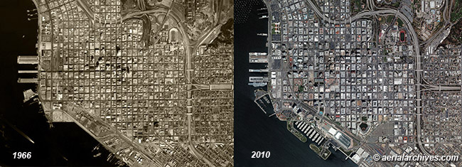
Aerial Archives' experience with attorneys, paralegals, investigators and litigation support firms includes large cases in which clients anticipated that aerial photography was likely to be dispositive. In several instances where the amounts at stake in litigation were substantial, clients retained Aerial Archives to locate obscure aerial photography that was buried in private (non-marketed) collections. These assignments has enabled Aerial Archives to develop a deep knowledge base of where specialized imagery is located. In cases in which the amounts at stake are smaller, the expense of high resolution satellite imagery is usually not economically justified. However, if less expensive aerial photography exists, it can be cost effective, often saving hours of legal time and frequently leading to a settlement. Where timing is critical for documentation of facts that disappear with the passage of time, particularly accidents likely to result in litigation, Aerial Archives is available to acquire imagery very rapidly. Aerial Archives has successfully completed rapid (same day) deployments to acquire aerial evidence before critical elements of that evidence are destroyed. The firm has completed numerous aerial photography missions where it gathered evidence in customized missions designed to support a case. Among the types of cases in which Aerial Archives has provided aerial photography are numerous environmental proceedings (air, water, ground contamination, wetlands etc.), boundary and easement disputes, eminent domain cases, construction disputes, criminal cases and investigations, accident documentation, fire litigation, landslide litigation and other quite unusual cases (please contact us if you would like additional details). For more information on how aerial photography and satellite imagery can help with your legal case, please contact Aerial Archives directly.
|
Researching Available Aerial Photography
and High Resolution Satellite Imagery
|
Aerial Archives provides in depth research services for historical and current aerial photographs and satellite imagery and can usually locate useful imagery that has already been collected for clients. When Aerial Archives receives a research request, it searches its own archives and queries third parties that the firm knows from previous experience are likely to hold imagery which could match a client's request. For either $50 for five business service or $100 for rush service (1-2 business days), Aerial Archives will research a request and generate a report which will indicate the date of acquisition, the scale or resolution of the imagery and the media on which it was acquired (black and white, color or infrared film in the case of older film, and color, panchromatic or multi-spectral in the case of digital acquisitions). This standardized research service is designed to accommodate most client needs. This service is, however, limited to researching only vertical (straight down) and not oblique (at an angle) aerial photography, and if requested, high resolution satellite imagery. It also does not include querying sources which Aerial Archives knows may have additional imagery, but which are either slow to respond to requests regarding the holdings of their archives or have unusually long turnaround times to produce imagery. Locating oblique (at an angle) as opposed to vertical (straight down) aerial photography is particularly time consuming since the content of the image is not as easily defined by simply tracing a polygon on a map. Oblique aerial photographs have a foreground and a background and therefore scale and resolution become variable depending on whether objects are in the foreground or background. Oblique aerial photographs present numerous other issues before a client can determine whether it will be useful to its case. Because of the time consumed in researching oblique aerial photography requests, many holders of such imagery are unable to profitably license their collections, particularly if they are not well indexed. Over time, because these collections are not commercially viable, they become more difficult to locate and sometimes they are discarded or recycled. Over the years, Aerial Archives has developed a database of remaining historical oblique aerial photography collections, including many which are no longer being made available commercially. Aerial Archives can assist clients in obtaining access to those dormant collections when the cost of this usually labor intensive process is justified. Aerial Archives bills for research services for oblique and difficult to locate aerial photography either by the hour plus expenses, or in some instances will contract for a specific project defined in advance between Aerial Archives and the client. Using these services is usually only cost effective in large cases. Among the sources not queried as part of the service provided in response to the standard research request is the National Archives. The National Archives aerial photography collection is extensive. The collection is particularly useful for locating early vertical and oblique aerial photography. Because of the workload that its staff needs to deal with, replies to research requests often take longer than the time frame provided for in our standard research request. Aerial Archives will assist clients is querying the National Archives directly or Aerial Archives will assist clients in expediting the process by engaging one of its contractors in the Washington, DC metro area, who will research the request in person and expedite the production of imagery, if necessary. For standardized research of aerial photography or satellite imagery, please use the pdf research request form. For additional information, please contact Aerial Archives.
|
Introducing Aerial Photography and Satellite Imagery Into Evidence
|
Aerial Archives provides a standard declaration that has been used by many attorneys over the last two decades to ensure that imagery provided by Aerial Archives is admitted into evidence. Aerial Archives also provides custom certifications. Fees for custom certifications of imagery are based on the amount of time counsel reviews drafts of custom declarations. Aerial Archives standard certification deliverable is a signed electronic copy. Signed originals are available for a small additional fee and are delivered via FedEx. Notarization of certifications is available, but Aerial Archives doesn't have a notary on staff at the moment. As a result, these services are billed based on the time involved by Aerial Archives staff to obtain the notarization, plus expenses. Aerial Archives only certifies aerial photography and satellite imagery that it has delivered to a client.
|
Presentation Graphics for Trials and Hearings
|
Presentation technology innovations have increased the number of presentation options available to legal professionals dramatically. Aerial photography and satellite imagery present unique issues where properly utilizing available technology for particular imagery can dramatically affect its impact on a judge, jury or other audience. When requested, Aerial Archives assists clients in optimizing the display of aerial and satellite evidence. For example, if display size is important and resolution is a concern, a client may be better served with a presentation of that evidence as a projection or a backlit display rather than a mounted print. If three dimensional visualization is useful, Aerial Archives will incorporate digital elevation model data into aerial photography or satellite imagery to create a three dimensional display that can be presented as two dimensional art or as a three dimensional model. Where appropriate for the presentation of aerial photography evidence, Aerial Archives will retain virtual reality professionals to create a presentation for legal clients. Please contact Aerial Archives to discuss options that you may wish to consider for the presentation of the aerial photography or satellite imagery evidence in your case.
|
Admissibility into Evidence
|
Aerial photography, satellite photography and other remote sensing data is generally admissible as evidence in most legal contexts including hearings and trials. See for example: Nutra Sweet Co. v. X-L Engineering Co., 227 F.3d 776 (7th Cir. 2000) and St. Martin v. Mobil Exploration & Producing US Inc., 224 F.3d 402 (5th Cir. 2000) Courts have also held that derivitive products from such imagery and data such as maps, for example, are admissible and that expert testimony interpreting what is shown by aerial photographs is admissible. These decisions are not limited to US courts and administrative tribunals. The International Court of Justice and judicial decisions in other jurisdictions concur with these holdings. See for example Case Concerning Kasikili/Sedudu Island (Namibia v Botswana) ICJ Rep 1045, International Court of Justice, December, 1999 (aerial photography and satellite imagery) and Case Concerning the Frontier Dispute (Burkina Faso/Republic of Mali), ICJ Rep. 554, International Court of Justice, December 22, 1986, (maps based on satellite imagery). These holdings also apply to specialized imaging techniques such as infrared aerial photography. See for example I&M Rail Link v. Northstar Navigation, 21 F. Supp.2d 849 (N.D. IL 1998). In addition US courts have upheld aerial surveillance in connection with future legal proceedings. See for example Dow Chemical Co. v. United States, 106 S. Ct. 1819 (1986).
|
References to Attorneys' Use of Aerial Photography
For a law firm's view on the use of aerial photography see Using Aerial Photography to Win Environmental Cases on the web site of Taft Stettinius & Hollister LLP. If you're aware of excellent publications by law firms or law professors of articles on the use of aerial photography, satellite imagery or other remote sensing data in legal proceedings, please let us know so that we can consider adding the references to the Aerial Archives web site. |
|
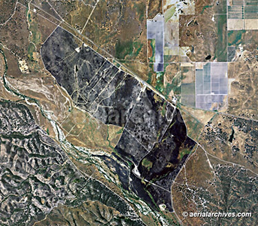
Water pollution issues are one of many examples of instances where aerial photography, satellite imagery and remote sensing data can be useful. Aerial photography can be useful for documenting both point source and non-point source water pollution, groundwater pollution, presence of some pathogens in the water and documentation of urban runoff, construction site storm water, and domestic, industrial and agricultural wastewater. Many instances of water pollution including thermal pollution can be documented using airborne thermography sensors or with archived aerial thermography data.
|
|
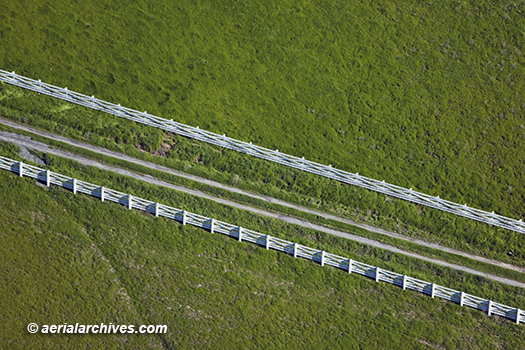
Disagreements over the location of a property line or the existance of an easement can sometimes be resolved by reference to historical aerial photography. Proving the existance of fences or similar strucutres at a specific date can be helpful in building a case. Fences, however, are often hard to discern from aerial photography. Rarely are they as prominently visible in historical aerial photography surveys as in the aerial photograph of the white fence on Sonoma Mountain in Petaluma, California shown above. Sometimes, fences are obscured by leaf cover, sometimes they are difficult to discern because available aerial photography does not have sufficient resolution. Sometimes the shadow of the fence can be detected even if the fence itself can't be seen in the aerial photograph. Shadows are more likely to be prominent when imagery is acquired during shorter days of the year when sun angles are lower, or if the imagery was acquired early or late in the day. It's essential that candidate aerial photography to show fences or similar evidence of boundaries have excellent resolution. For vertical (straight down) aerial photography, anything with a resolution that is broader than 1:12,000 (e.g. 1"=1000') or a 6" pixel is almost always inadequate. For smaples of aerial photography resolution please consult aerial photography resolution samples. Sometimes, however, there are other patterns in the use of the land besides a fence which can provide the required evidence. To prove a case using aerial photography to show such uses, it may be necessary to retain an expert witness to provide photo interpretation services. For assistance in planning your aerial photography and satellite imagery strategy for your next case, please contact us.
|