|
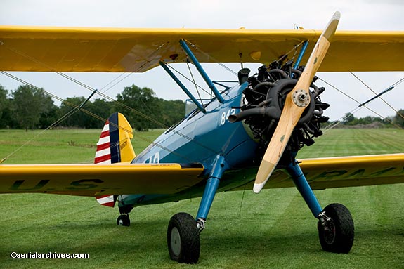
Over 3000 new oblique color aerial photographs of the southwestern United States are now available--all shot from the Stearman shown above.
Aerial photographs from the trip are accessible through an interactive map
or by using the links below.
Among the cities, towns, geographic features and locations covered during this trip are:
Wharton, Texas;
El Campo, Texas;
Louise, Texas;
Edna, Texas;
Pearsall, Texas;
Hondo, Texas;
Kerrville, Texas including the Mooney Aircraft company factory;
the Texas hill country;
Junction, Texas;
Sonora, Texas;
Ozona, Texas;
Bridgestone Racetrack, Fort Stockton, Texas;
Toyavale, Texas;
Van Horne, Texas;
El Paso, Texas;
the Rio Grande river;
Ciudad Juarez, Mexico;
Deming, New Mexico;
Las Cruces, New Mexico;
Lordsburg, New Mexico;
Katherine Playa, New Mexico;
Peloncillo Mountains Wilderness Area;
San Simon, Arizona;
Dos Cabezas Mountains Wilderness Area;
Wilcox Playa;
Benson, Arizona,
Mescal, Arizona,
Tucson, Arizona, including the University of New Mexico at Tucson and the
military aircraft boneyard at Davis Monthan Air Force Base;
Marana, Arizona;
Pinal Airport, including the commercial aircraft boneyard;
Casa Grande, Arizona;
Firebird Lake, Arizona;
Phoenix, Arizona, including Phoenix Sky Harbor International airport and Squaw Peak;
Deer Valley airport, Arizona;
Lake Pleasant, Arizona;
Quintero Golf Course, Arizona;
Glendale airport, Arizona;
Phoenix Goodyear airport, Arizona;
Buckeye, Arizona;
Tonopah, Arizona;
Hummingbird Springs Wilderness Area, Arizona;
Big Horn Mountains Wilderness Area, Arizona;
New Water Mountain Wilderness Area, Arizona;
the Plomorosa Mountains;
Quartzsite, Arizona;
the Colorado river;
Blythe, California, including the fire and fire fighting efforts;
the Salton Sea, California;
Thermal, California;
Palm Springs, California;
Banning, California;
San Bernadino, California;
Sheep Mountain Wilderness Area, California;
Palmdale, California;
Tehachapi, California;
Bakersfield, California;
Oildale, California;
Delano, California;
Pixley, California and the Pixley National Wildlife refuge;
Tulare, California;
Visalia, California;
Modesto, California;
Stockton, California including the Port of Stockton;
the Sacramento San Joaquin river delta;
Rio Vista, California;
Lake Berryessa, California;
and
the Pope Valley wine growing region;
To view aerial photographs of the highlights, please consult
the index of southwestern USA aerial photography.
For additional information, please contact Aerial Archives, if you would like to license a photograph or purchase a print from this collection.
|