

Aerial Maps and Satellite Imagery of Ventura County, California
Ventura County Aerial Photography For Immediate Download
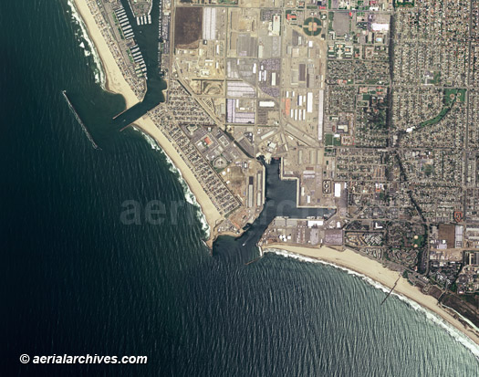
An extensive selection of aerial maps, aerial photographs and high resolution satellite imagery of Ventura county, CA is available Aerial Archives, as well as oblique aerial photography. Available imagery includes georeferenced aerial photography and satellite imagery of Ventura county delivered both as prints and digital files. Specialized services include delivery of geotiffs, customized labelling of aerial maps and output to specialized media. The coverage of aerial maps and satellite imagery of Ventura county can also be completely customized both with respect to scale and to show the county or only a specific community. Aerial map and satellite imagery coverage includes the cities of Camarillo, Fillmore, Moorpark, Ojai, Oxnard, Port Hueneme, Santa Paula, Simi Valley, Thousand Oaks and Ventura and the communities of Bardsdale, Bell Canyon, Casa Conejo, Casitas Springs. Channel Islands Beach. El Rio, Faria Beach, La Conchita, Lockwood Valley, Meiners Oaks, Mira Monte, Mission Oaks, Newbury Park, Oak Park, Oak View, Piru, Point Mugu, Saticoy, Somis and Woods Ranch. The aerial map of Port Hueneme, Ventura County, California shown on this page is available for immediate online license or prints or, to obtain it optimized to your needs or as a higher resolution file please contact Aerial Archives directly and reference the ID number in the caption to the photograph. For current aerial photography and satellite imagery coverage of Ventura county, California please contact us. Additional information about oblique (at an angle) aerial photography of Ventura county is available at aerial photographs of Ventura county. For historical aerial photo maps of Ventura County, California available for immediate online license or prints please visit historical aerial photographs of Ventura. For historical research of aerial photography and aerial maps of Ventura county, California we recommend that you use the research request form. Additional information about the process of researching historical aerial photography for your location is available at aerial photography research.
|