
Historical Aerial Photographs of Cleveland, Ohio
Historical Aerial Photographs of Cleveland For Immediate Download
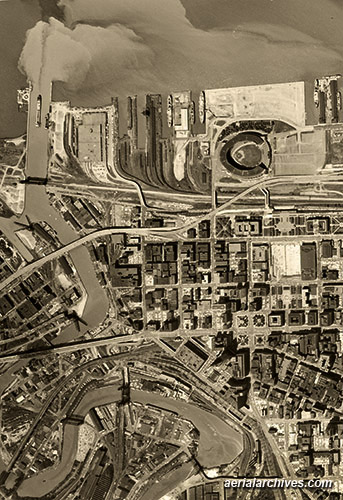
Historical Aerial Photograph of
Water Pollution and Sediment as it Pours into Lake Erie
From the Cuyahoga River
Cleveland, Ohio
1962
Image ID: AHLV3294
© aerialarchives.com
Terms of Image Use |
Immediate License or Prints
Feedback
|
An extensive selection of high resolution historical aerial photography of Cleveland is available from Aerial Archives. Historical aerial photographs are available for advertising and editorial use as well as for use to establish facts about historical conditions by law firms, investigators, and researchers conducting due diligence. Aerial Archives also provides current aerial photographs which can be used to make a then and now comparision with the historical aerial photography. In addition to high resolution historical aerial photographs of the Cleveland metropolitan area, current high resolution aerial maps are also available. Please consult aerial maps of Cleveland for details.
The historical aerial photograph of effluent flowing from the Cuyahoga river into Lake Erie at the Port of Cleveland shown above is available for immediate license or prints.
|
Historical Aerial Photographs of downtown Cleveland
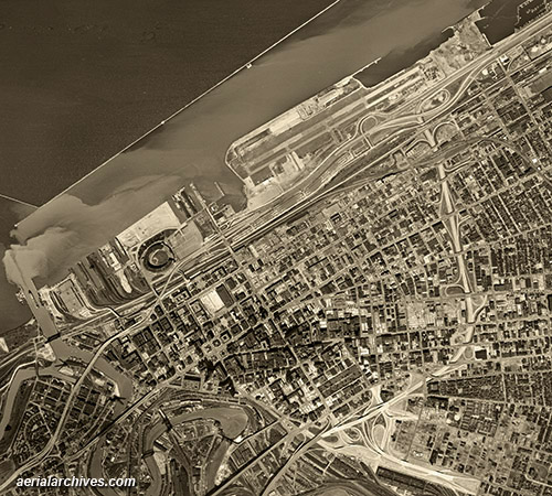
Historical Aerial Photograph of
downtown Cleveland, the Port and Waterfront
Burke Lakefront Airport
Cleveland, Ohio
1962
Image ID: AHLV3297
© aerialarchives.com
Terms of Image Use |
Immediate License or Prints
Feedback
Historical Aerial Photographs of the
Cuyahoga river industrial area, Cleveland, Ohio
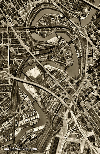
Historical Aerial Photograph of
downtown the industrial area including steel mills
along the Cuyahoga River
Cleveland, Ohio
1962
Image ID: AHLV3300
© aerialarchives.com
Terms of Image Use |
Immediate License or Prints
Feedback
|
The historical aerial photograph of the industrial area along the Cuyahoga river in Cleveland, Ohio shown above is available for immediate license or prints.
|
Historical Aerial Photographs of
Cleveland, Ohio in Winter
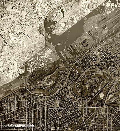
Historical Aerial Photograph of
Ice On Lake Erie beginning to break up
at the mouth of the Cuyahoga River
Cleveland, Ohio
1962
Image ID: AHLV3422
© aerialarchives.com
Terms of Image Use |
Immediate License or Prints
Feedback
|
The historical aerial photograph of ice on Lake Erie at the mouth of the Cuyahogo River in Cleveland, Ohio shown above is available for immediate license or prints.
Aerial Archives provides research services for historical aerial photographs and can usually locate an useful historical aerial photograph for clients.
For historical research of aerial photography of Cleveland, we recommend that you use the pdf research request form. Additional information about the process of researching historical aerial photography for your location is available at aerial
photography research.
A selection of aerial photographs of Cleveland are available for
immediate download or prints
|
Copyright by Aerial Archives
