

Aerial Photographs of the Napa Valley for Immediate Download
|
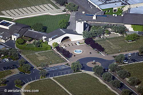
An broad selection of aerial photographs of the Napa valley in northern california and the surrounding wine country is represented in the library of Aerial Archives. This aerial photography collection includes aerial photographs of specific wine production processes, such as wine fermentation tanks and aerial photographs of the various stages in growing grapes, vineyards in various stages of development and tasting rooms. This collection of aerial photographs covers the California wine industry with a particular emphasis on the Napa and Sonoma valleys, and the Russian River winemaking area and other more rural areas. Aerials of the California Wine Growing Regions contains a description of the other wine growing regions in California covered by the collection. The collection also includes aerial photographs of vineyards during the various seasons. Opus One and Mondavi, the Carneros District and the mountain areas are among the vineyard areas represented in the collection. The archive includes the wine train and numerous detailed features about the Napa valley. This aerial photography collection also includes oblique aerials of the entire Napa valley including views of each of the individual cities and townships of the Napa valley, including American Canyon, Calistoga, the City of Napa, St. Helena and Yountville as well as many of the Napa valley vineyards and resorts, golf courses and some of the larger accommodations in the Napa Valley. The archive also contains are a comprehensive oblique view of the entire Napa valley which has been published in several books on wine. In addition, the archive contains a comprehensive collection of vertical Napa valley aerials including aerial photos of the Napa valley area in color, infrared and black and white. Georeferenced aerial maps of the Napa valley are also available which show an aerial view of all or a portion of the valley. The aerial photograph of the Mondavi Winery in Oakville, California shown above is available for immediate online license or prints or, to obtain it optimized to your needs please contact Aerial Archives directly and reference the ID number in the caption to the photograph. For current aerial photography of the Napa Valley, please contact Aerial Archives directly. For specific requests for Napa valley historical aerial photos and other portions of the wine country near the greater San Francisco Bay Area please use the research request form. Additional information about obtaining existing aerial photography of the Napa valley and surrounding wine country is also available at aerial photography research and at aerial photography research FAQs. |