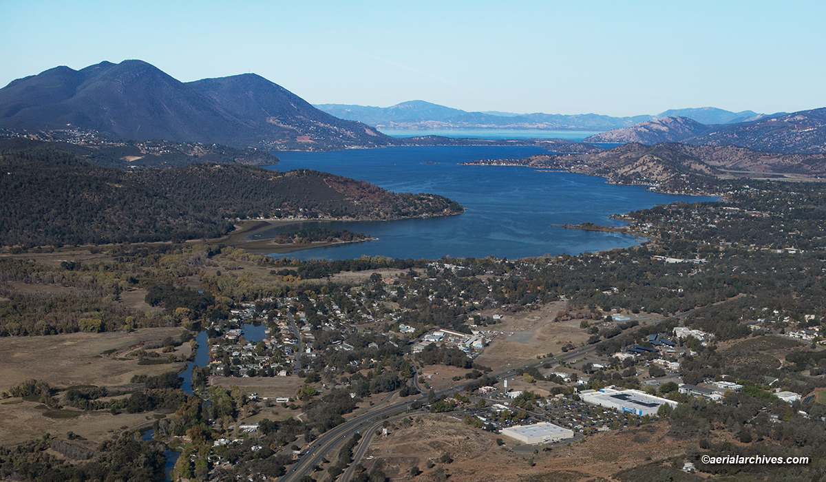
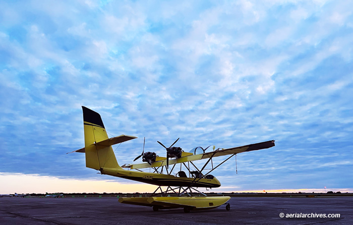
Clear Lake Splash-In | Lakeport, CA | 2023

Clear Lake Seaplane Splash-In, Lakeport, Lake County, California
The volunteer Sea Scouts help Chris Brown reposition his turbo Cessna 206, TU206G, N247CB
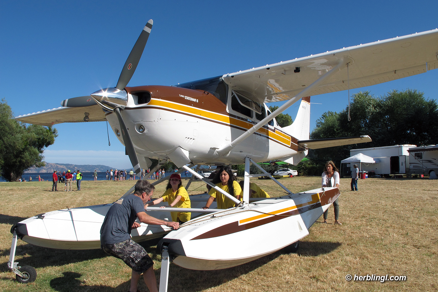
at the Clear Lake Seaplane Splash-In, Lakeport, Lake County, California
Image ID: AHLC3935
© Herb Lingl/aerialarchives.com

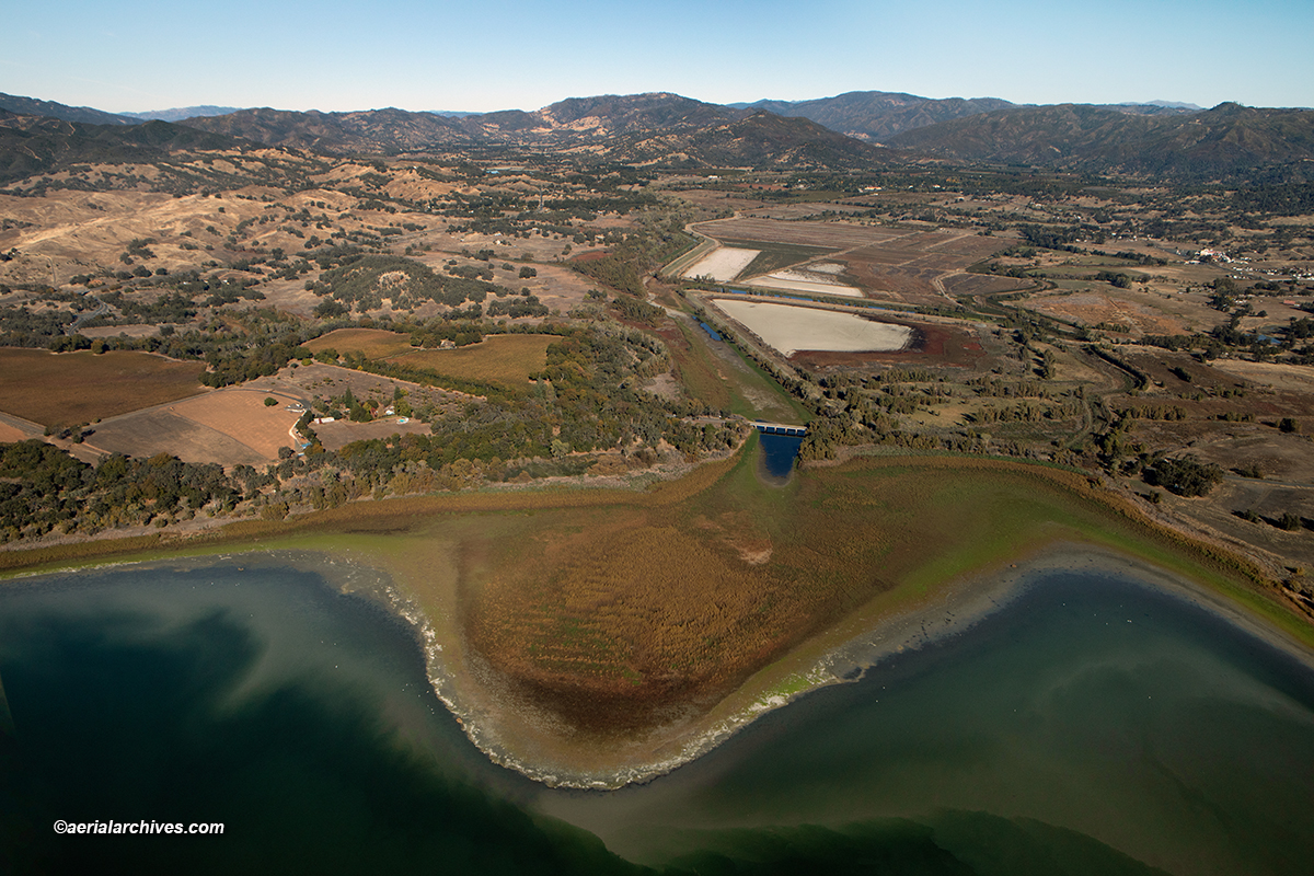
The 2023 Clear Lake Splash-In takes place Friday, Sept. 22 through Sunday, Sept. 24 in Lakeport, California.

The event features a display of seaplanes, educational seminars and an opportunity to learn about careers in aviation. It draws pilots and people interested in aviation to the Lakeport for the weekend and this year, it has been combined with the Taste in Lakeport food and wine festival to showcase all that Lakeport has to offer.

Clear Lake Splash-In | Lakeport , CA | 2023 features a variety of free seminars, an evening reception with an aviation exhibition, a dinner for pilots and a display of seaplanes coming to Clear Lake for the event.

The Splash-In begins with a Friday evening with a dinner for seaplane pilots at the Lakeport residence of Tom and Ruth Lincoln. Tom Lincoln is the president of the Lake County Airmens Association. Registration for the dinner is available at Seaplane Pilots Dinner.

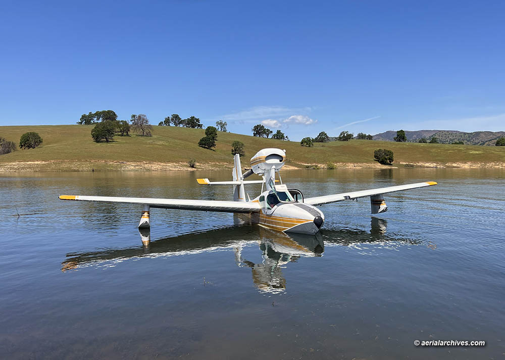
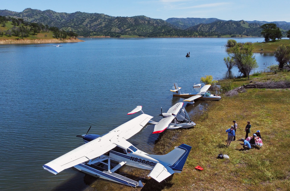
One of the highlights of the event will occur on Saturday, Sept 23, when a display of participating seaplanes will be held at Lakeport’s Library Park. Seaplanes arriving for the Splash-In include two Cessna 185s on floats, a Cessna 206 on floats, two Grumman Widgeon aircraft, a Lake Buccaneer, a Quicksilver on floats, a SeaMax and a SeaRey.

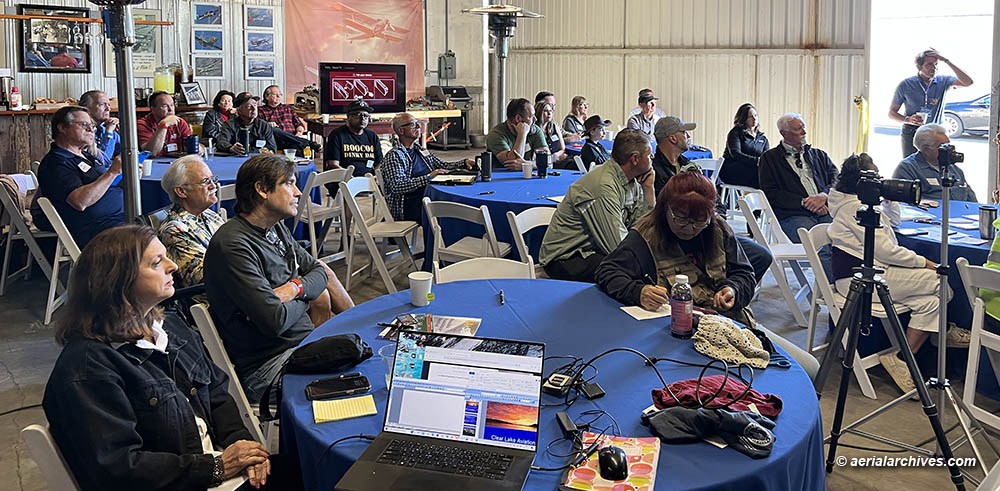
Saturday also features a full day of seminars about flying seaplanes, obtaining scholarships and career opportunities for young people in aviation.

The seminars take place within walking distance of the displayed seaplanes in the Council Chambers in Lakeport’s City Hall. The seminars are free, but registration is required due to limited seating available in the Council Chambers.

The seminar program is available at: Clear Lake Splash-In Seminar Program.

Registration for the free seminars is available at Clear Lake Splash-In Seminar Registration.

Seaplane pilots interested in participating in this year’s Splash-In can still register to participate at Clear Lake Splash-In Aircraft Registration.

The first 20 pilots who register to participate in the Clear Lake Splash-In will receive a free ticket to the Taste In Lakeport food and wine festival. The festival begins at 5:30pm on Saturday, Sept 23 and is within walking distance of seaplane display. Details about the Taste In Lakeport are available at: Taste In Lakeport.

The Splash-In also features an exhibition at the Historic Courthouse in Lakeport entitled Over Water: An Aviation History of Lake County. The museum is hosting a reception for exhibition from 5-7:00pm on Saturday, September 23. Attending the reception is free but requires registration. Registration for the reception is at Museum Reception Registration.

Pilots who are interested in getting back in the cockpit after a lapse in flying will be interested in the Aircraft Owners and Pilots Association’s (AOPA) Rusty Pilots Seminar entitled Getting Back to Flying is Easier Than You Think. This seminar takes place on Sunday, Sept 24 from 9:00 am-12:30 pm at the offices of Esther Formula, USA in the Work Right Building near Lampson Field airport (1O2). This seminar will be lead by Captain Brian Schiff, a 25 year pilot for American Airlines who currently flies the MD-80.

To register for the AOPA seminar with Captain Schiff, please visit:

Getting Back to Flying is Easier Than You Think with Brian Schiff.

More information about the Clear Lake Splash-In | 2023 is available at Clear Lake Splash-In.

The Lakeport Street Main Street Association (LMSA) is producing the Clear Lake Splash-In. The LMSA supports businesses in Lakeport, California by organizing events and seminars that help businesses in Lakeport thrive. To learn more please visit Lakeport Street Main Street Association.

AOPA is the world’s largest community of pilots, aircraft owners and aviation enthusiasts with representatives based in Frederick, MD., Washington, D.C., and seven regions across the United States. To learn more please visit Aircraft Owners and Pilots Association.

The Clear Lake Flying Club is producing the Clear Lake Splash-In Seminars. The flying club produces seminars, workshops and aviation events to promote aviation in Lake County, California and provides resources to assist young people in Lake County to pursue career opportunities in aviation. To learn more, please visit the Clear Lake Flying Club.

For additional details about the event, please visit the following web pages:

Clear Lake Splash-In

Clear Lake Splash-In Facebook Page

Clear Lake Flying Club Splash-In Media Release

Photographs of previous Clear Lake Splash-In events are available at:

Clear Lake Splash-In Photographs.

Share

Alaska and British Columbia Aerial Photography Advance Shooting Notice | July 9-Aug 1, 2023

aerial photograph of the south Coastal Mountains, British Columbia, Canada,
aerial photograph of the south Coastal Mountains, British Columbia, Canada
Image ID: AHLE1680
© Herb Lingl/aerialarchives.com

I’ll be creating new aerial photography and video in Alaska and British Columbia from July 9 through August 1. I’ll be shooting aerial photography and video in Anchorage and the vicinity (Homer, Seward, Talkeetna and Valdez) first. Then I’ll be shooting along the Alaskan and British Columbia coastlines.

Along the Alaskan coastline, I intend to create aerial photographs and video of Cordova, Glacier Bay National Park and Preserve, Juneau, Ketchikan, Sitka and Yakutat. I’ll also be photographing the islands, shorelines, coves, bays, glaciers and mountains along the way.

In British Columbia I intend to create aerial photographs and video of Cortenay, Comox, Nanaimo, Port Hardy, Tofino, Victoria and Vancouver and the geographic features of Vancouver Island.

I’ll also be photographing seaplanes, seaplane operations and seaplane bases. If you have a unique seaplane that you think would be a good candidate for this project, I would be grateful if you contact me.

I have flexibility to accept assignments to create Alaska and British Columbia aerial photography and video in other portions of Alaska and British Columbia during this time.

If you have a project you’d like photographed in either Alaska or British Columbia, please contact me.

To view aerial photographs of Alaska and British Columbia available immediately please visit:

Aerial Photographs of Alaska

Aerial Photographs of British Columbia

License the photograph shown above or purchase a print

Share

Clear Lake Aviation Gathering | 2023

Lake Buccaneer,  LA4-200, N6176V, amphibious aircraft approaches a beach at Lake Berryessa during very calm conditions during the Clear Lake Aviation Gathering Fly Out on April 23, 2023
Lake Buccaneer, LA4-200, N6176V, amphibious aircraft approaches a beach at Lake Berryessa during very calm conditions during the Clear Lake Aviation Gathering Fly Out
Image ID: AHLC4670
© Herb Lingl/aerialarchives.com

A diverse group of seaplane pilots, aerial photographers and other aviation professionals attended the Clear Lake Aviation Gathering that took place at Lampson Field Airport (1O2) in Lakeport, California on April 22 and 23, 2023.

The Clear Lake Flying Club (CLFC) hosted the conference and produced it with the Professional Aerial Photographers Association (PAPA).

Herb Lingl, education director of the CLFC noted that “One of the conference objectives is to develop opportunities for young people in Lake County, California to pursue careers in aviation.” Details about the youth program are at Clear Lake Flying Club Youth Program.

Conference Sessions

Attendees at the Clear Lake Aviation Gathering listen to the presentation by Dr. Stephen Bateman of AOPA.  Among the pilots in the photograph from left to right are Amy Hartsfield, Rick Long, Mike Hayes, Tom Beattie, Tom Lincoln, Bryan Sydnor, Jason Johanson, Gordon Mills, Missy Lee, Tim Neuharth, Kent Carlomagno and Tom Wasson
Attendees at the Clear Lake Aviation Gathering listen to the presentation by Dr. Stephen Bateman of AOPA. Among the pilots in the photograph from left to right are Amy Hartsfield, Rick Long, Mike Hayes, Tom Beattie, Tom Lincoln, Bryan Sydnor, Jason Johanson, Gordon Mills, Missy Lee, Tim Neuharth, Kent Carlomagno and Tom Wasson.
Image ID: AHLC4669
© Herb Lingl/aerialarchives.com

The Aircraft Owners and Pilots Association (AOPA) sent Dr. Stephen Bateman to the conference from Frederick, MD to make presentations about flying clubs and the AOPA Foundation High School STEM Aviation Curriculum which AOPA makes available to high schools at no cost. Details about the curriculum are at AOPA Foundation High School STEM Aviation Curriculum.

Paul Koscheka, the Federal Aviation Administration’s FAASTeam Program Manager at the Sacramento FSDO, provided a briefing on the WINGS Pilot Proficiency Program. Three of the seminars at the conference qualified for WINGS credit.

Additional presenters at the conference included Tom Beattie, instructor and test pilot for ICON Aircraft, Kent Carlomagno, Terry Hayes from Foothill Aviation and the Backcountry Flying Experience, Gordon Mills from Alpine Aviation, Missy Lee, the owner of Alaska Floats and Skis, Herb Lingl, Rick Long, Jason Johanson who provides multi-engine seaplane training in a Twin Seabee and Tom Wasson from Tom’s Aircraft Enterprises.

During the session entitled Which Seaplane Is Right for You?, Tom discussed the ICON A5, Kent the SeaMax, Gordon the Lake Buccaneer, Rick the Quicksilver on floats and Jason the Twin Seabee.

Terry, Gordon, Missy and Jason were the panelists for the Emergency Procedures in Seaplanes session. They discussed emergency procedures as they applied to the specific flying environments in which they operate.

The conference included a session about the History of Aviation in Lake County. Lake County Museums curator J. Clark McAbee prepared a presentation about Navy and Pan Am seaplane operations at Clear Lake entitled Wings Over Water: Flying Boats on Clear Lake circa 1939-1958. Retired high school teachers Miles Turner and John Wiegand described the high school aviation programs they taught at the Lower Lake and Kelseyville High Schools in the 1970s. Paul Loewen, who built a globally recognized Mooney modification firm based at Lampson Field, described the airport’s history from the 1960s, his experience teaching aviation at Mendocino Community College and his experience flying a Fleetwings Sea Bird, a high school aviation project that Paul and his wife Shery flew to Clear Lake with Paul’s high school aviation teacher.

The conference session about the Future of Aviation in Lake County examined plans for the future of aviation in Lake County, including the possible construction of seaplane docks and a seaplane ramp in Lakeport, CA, and a presentation by Dave Dietz of Armstrong Consultants, which specializes in airport engineering, about developing vacant land at Lampson Field for the construction of new hangars.

Seaplane Flight Training on Clear Lake

Gordon Mills from Alpine Aviation provided flight training in the Lake Buccaneer, LA4-200, N6176V, shown at the top of this page to conference attendees who booked flight training before the conference.

Aerial Photography Exhibition

The conference included an aerial photography exhibit and competition. Aerial photographer Amy Hartsfield, PAPA Vice President of Programs, made a presentation about the Professional Aerial Photographers Association and presented information about the aerial photographers whose work was selected to be exhibited at the conference.

Wine Tasting and Catered Hangar Dinner

After the conference sessions, attendees sampled some of the finest wines made in Lake County. These included wines from the Shannon Family of Wines and Lincoln Wines produced by Tom and Ruth Lincoln.

The conference dinner was catered by Lake Event Design, Lake County’s premier event company.

After the dinner, conference attendees voted Jean Luc Kaiser’s aerial photograph of the private Islet of Loreto in northern Italy as their favorite photograph on display. The islet is close to Aero Club Como, one of the oldest seaplane flying clubs in the world. Jean Luc, who owns L’Europe vue du Ciel, a French aerial photography company, received a cash prize for his winning entry.

Raffle Prizes

Raffle winners also received their prizes after the dinner. Donors of raffle prizes benefiting the Clear Lake Flying Club Youth Aviation Program included:

Kent Carlomagno
Mike and Terry Hayes
Tom and Ruth Lincoln and
Herb Lingl

and

Aerial Archives
Aircraft Owners and Pilots Association
Airport Muse
Clear Lake Flying Club
Clear Lake Pilot Supplies
Meadowlark Publishing
Nalas Cleaning Expertise
Professional Aerial Photographers Association and
Tailwheel Ferry Pilot

Fly Out to Lake Berryessa

Seaplanes beached at the shoreline of Lake Berryessa during the Clear Lake Aviation Gathering, as a Lake Buccaneer approaches (background left).
© Byron Hernandez
Image ID: AHLC4668

Sunday featured a seaplane fly out to Lake Berryessa.

The fly out included an ICON A5 flown by Tom Beattie, two Lake Buccaneers, one flown by Gordon Mills the other by Henry Roberson from Air Carriage Inc. and a Cessna 206 on floats flown by Byron Hernandez.

More Information

The full conference program is at Clear Lake Aviation Gathering 2023 Program.

An article that appeared in the magazine Water Flying about the conference is at Water Flying article.

An article that appeared in the magazine In Flight USA about the conference is at In Flight USA article.

An article that appeared in the Lake County Record Bee about the conference is at Record Bee Article-Print and Record Bee Article-Online.

More information about Lampson Field airport is at Lampson Field.

For over forty years, Lake County has hosted the Clear Lake Splash In. This year’s Splash In is scheduled to take place on September 23-24, 2023 in Lakeport. Photographs of previous Clear Lake Splash In events are at photographs of the Clear Lake Splash In.

A selection of aerial photographs of Lake County are at aerial photographs of Lake County.

More information about Lake County, California is at Lake County Visitor Information.

Share

Aerial Photographs of Drought at California’s Clear Lake

Piers in North Lakeport, Lake County, California do not reach Clear Lake during a drought, November, 2022
aerial photograph of piers in North Lakeport, California
Image ID: AHLE1726

Aerial photographs of the drought at California’s Clear Lake show the lake at historically low levels. Many residential piers around Clear Lake are now far from the water’s edge. Particularly impacted are areas where Clear Lake has a relatively shallow depth drop off. The residential piers in the photograph above are an example of the numerous piers in North Lakeport that are similarly impacted by Clear Lake’s low water level. There are similar high and dry piers in Lakeport, Lower Lake, Clearlake and other locations around the Lake with shallow shorelines.

Numerous residential developments with channels designed to provide access to Clear Lake such as Lakeport Lagoons are completely dry, some overgrown with weeds.

aerial photograph piers at Lakeport Lagoons, Clear Lake in Lakeport, Lake County, California during the drought, November, 2022
aerial photograph of piers at Lakeport Lagoons, Lakeport, CA
Image ID: AHLE1730

The Rumsey Gage reading indicates the water level of Clear Lake. Zero Rumsey equals 1318.257′ above mean sea level, the normal low level of Clear Lake. Cache Creek Dam controls the level of Clear Lake. The Yolo Water and Power Company built the dam on the south fork of Cache Creek in 1914. The Yolo County Flood Control and Water Conservation District now owns and operates Cache Creek Dam. Yolo County has rights to water in Clear Lake covered by several decrees one of which stipulates that Clear Lake’s water level shall be maintained between zero and 7.56′ above Rumsey. If Clear Lake is “full” on May 1, defined as 7.56′ above Rumsey, Yolo County may withdraw up to 150,000 acre feet of water. If Clear Lake is 3.22′ above Rumsey or lower on May 1, Yolo may not withdraw water from the Lake.

aerial photograph of Cache Creek, Lower Lake Lake County,
aerial photograph of Cache Creek and Clear Lake.
Image ID: AHLE1731

When Clear Lake is full it has a surface area of 43,790 acres and contains 1,155,000 acre-feet of water. When the Lake is at Zero Rumsey it has a surface area of 39,170 acres and contains 842,000 acre-feet of water. As of November 6, 2022, the Lake is at less than 2.6′ below Rumsey.

Clear Lake’s evaporation rate during the summer is approximately 3′ according to Lake County’s Department of Public Works Water Resources Division.

The drought has dramatically changed some of the creeks and sloughs around the Lake together with the nature of their surrounding habitat.

aerial photograph of Rodman Slough, Lake County, California during a drought, November, 2022
aerial photograph of Rodman Slough during drought conditions
Image ID: AHLE1725

Rodman Slough is a wetland that drains into Clear Lake. It is fed by Scotts Creek and Middle Creek and is an important habitat for wildlife including fish, birds and amphibians. Rodman Slough is a remnant of a much larger wetland area drained for farmland that included Tule Lake, a seasonal lake that forms in the winter when Scotts Creek overflows. The slough is an important stopover point for migratory birds. It has a large rookery of great blue heron and is an important breeding and nursery area for black bass, catfish and black and white crappie.

aerial photograph of a flock of American White Pelicans at Clear Lake
Image ID: AHLE1714

Hundreds of American White Pelicans spend the winter at Clear Lake. The flock shown above is located on a sandbar just outside of Clear Lake State Park. The white pelicans are particularly attracted to Clear Lake because it is a shallow lake making it easier for them to locate minnows than they could at adjacent bodies of water such as Lake Pillsbury or the Indian Valley Reservoir. Because Clear Lake is a shallow lake, the impacts on the Lake’s shoreline can be dramatic during droughts and floods.

Please use these links to view additional related photography:

Aerial Photographs of Lake County, California

Aerial Photographs of the Drought in the Western United States

Aerial Photographs of Wetlands

Photographs of the Drought at Clear Lake

Share

Aerial Photographs of the Response to Hurricane Ian Staged at the Sebring International Raceway

aerial photograph of Sebring International Raceway during the staging of the Hurricane Ian response
aerial photograph of Sebring International Raceway during the staging of the Hurricane Ian response, September 30, 2022, Sebring, Florida
Image ID: AHLE1665

Entirely by accident I had the opportunity to create aerial photographs of the response to Hurricane Ian Staged at the Sebring International Raceway.

On September 26, 2022 I started training for the multi engine seaplane rating with certified flight instructor Ben Lively of Lockwood Aviation in the Air Cam at the Sebring Regional Airport (KSEF). The Air Cam was originally developed by Phil Lockwood to fly photo missions in the Ndoki Rain Forest in the northern Congo Basin.

Lockwood Aircraft Air Cam N51SC parked at Sebring Regional Airport (KSEF) at dawn
Image ID: AHLE1599

The FAA check ride was scheduled for September 29 Jon Brown at the Jack Brown’s Seaplane Base in Winter Haven, Florida. Hurricane Ian was approaching, however, with landfall forecast for on the evening before the check ride. The hurricane, the fifth most powerful to hit the United States, ultimately made landfall south of Sebring, but did damage Sebring. Among the casualties was a Piper Warrior that was tied down at KSEF. A tornado caused by the hurricane pulled the tie downs and aircraft from the tarmac and tossed it on its back.

Once the weather passed, visibility was outstanding. Ben and I began training again on Friday and by Saturday I noticed the massive response by utility services vehicles being staged at the Sebring International Raceway. I began taking aerial photographs of the response to Hurricane Ian staged at the raceway from the Air Cam on the afternoon of September 30.

Equipment being staged from the Raceway included Duke Energy utility trucks to help restore power and equipment provided by the US Army Corp of Engineers.

Jon Brown rescheduled the check ride for Sunday, October 2 despite the fact that it was a weekend and power was still out at Winter Haven. Jack Brown’s Seaplane Base is a world renowned seaplane training base that has certified more than 22,000 seaplane pilots in the 57 years since Jon’s father, Jack founded the base.

Flying the Air Cam back from Winter Haven after the check ride I documented some of the aftermath of the hurricane from the air, including extensive flooding even in Florida’s inland areas.

aerial photograph of flooding at Avon Park Executive Airport
aerial photograph of flooding at Avon Park Executive Airport (KAVO), Avon Park, Florida after Hurricane Ian; runway 10-28 is being used as a staging area to the response to Ian’s destruction Image ID: AHLE1689

When I returned to KSEF in the middle of the afternoon on October 2, most of the equipment being staged out of Sebring International Raceway was still in the field. Most of it returned to the Raceway every evening in a massive procession.

aerial photograph of the Sebring Regional Airport (KSEF) with the Sebring International Raceway in the background, Sebring, Florida
Image ID: AHLE1690

Please use these links to view additional related photography:

Aerial Photographs of the Sebring International Raceway

Aerial Photographs of Airports

Aerial Photographs of Florida

Photographs of the Lockwood Air Cam

Share

New Aerial Photography of the Pacific Northwest: British Columbia, Washington & Oregon | August, 2022

aerial photograph of the Klinaklini Glacier, British Columbia, Canada
Image ID: AHLE1599

From August 12 through August 31, I had the opportunity to create new aerial photography of the Pacific Northwest.

Flying over the mountains from Bella Coola, British Columbia to Comox, Vancouver Island brought me to the Klinaklini Glacier shown in the aerial photograph above.

The Klinklini Glacier is the largest glacier in the Coast Mountains of British Columbia and one of the largest glaciers in North America. It is located west of the Klinaklini River and the head of the Knight Inlet. Scientists are studying its changes and retreat over time. The glaciers of British Columbia contain a large portion of the total water supply of Canada.

Visibility was exceptional during most of the days during which I acquired new aerial photography of the Pacific Northwest.

Areas I photographed in British Columbia include Vancouver, Victoria, the Frasier River Valley, the Okanagan Valley, much of the eastern shoreline of Vancouver Island and the Coast Mountains of British Columbia.

Atmospheric conditions in Seattle, the remainder of Puget Sound, Portland and the Columbia River were all exceptional for aerial photography while I was working there.

To see the details of this photography flight, please download this interactive pdf which has the route of flight shown in the graphic below together with links to the locations and to larger versions of the photographs.

Please use these links to view additional aerial photography for the locations covered by this trip:

Aerial Photography of British Columbia

Aerial Photography of Washington

Aerial Photography of Oregon

Aerial Photography of Vancouver, BC

Aerial Photography of Portland, OR

License Image ID: AHLE1599 shown above or purchase a print

The Route of the Flight

Pacific Northwest Aerial Photography Aerial Archives 2022
Route of Flight for Aerial Photography of the Pacific Northwest, August, 2022
Share

Aerial Photographs of Wildfire Smoke in California

An aerial photograph of wildfire smoke in the mountains of Humboldt County, California
aerial photograph of wildfire smoke in the mountains of Humboldt County, California
Image ID: AHLE1596

Herb Lingl took this aerial photograph of wildfire smoke in the mountains of Humboldt County, California from an altitude of approximately 9,500′ above sea level on August 31, 2022. It is part of a series of aerial photographs documenting wildfires in California.

The volume of smoke being generated by this and other fires burning in the western portion of North America is massive. The smoke reaches high altitudes and spreads to distant locations. Wildfire smoke from West Coast wildfires has reached New York City and Washington, DC in recent years.

The National Oceanic and Atmospheric Administration’s Global Systems Laboratory created a striking animated graphic showing the spread of wildfire smoke. The New York Times published it in a 2021 article entitled See How Wildfire Smoke Spread Across America.

The smoke from the wildfire shown above is from the Six Rivers Lightning Complex Fire. It has already burned well over 30,000 acres.

Smoke is a particularly concerning wildfire hazard. It is certain to have widespread long term impacts on human health. Particulate matter, especially small particles (less than 2.5 microns in size) can be inhaled into the deepest parts of the lungs causing adverse heart and lung effects. While these shorter term impacts have received the most attention, there are now an increasing number of studies on the long term impacts on human health of wildfire smoke. The chemicals in wildfire smoke are correlated with an increase in the risk of all kinds of cancer. Among the other long term impacts of wildfire smoke identified by these studies are premature mortality, increased respiratory and cardiovascular disease, as well as mental health issues.

aerial photograph of wildfire smoke in the mountains of Humboldt County, California
Image ID: AHLE1597

To view more aerial photography of California’s wildfires please visit:

Aerial Photography of California Wildfires

License Image ID: AHLE1596 shown above or purchase a print

License Image ID: AHLE1597 shown above or purchase a print

To view more aerial photography of Humboldt County, California, please visit:

Aerial Photographs of Humboldt County

Share

Aerial Photography Shooting Schedule Portland, Seattle and the Pacific Coastline: August 10-August 24, 2022

This aerial photograph of Kenmore Air Harbor, Kenmore, Washington shows Kenmore's corporate headquarters, terminal and seaplane maintenance facility
This aerial photograph of Kenmore Air Harbor, Kenmore, Washington shows Kenmore’s corporate headquarters, terminal and seaplane maintenance facility
Image ID: AHLV4753

Aerial Archives photographer Herb Lingl will be shooting aerial photography and video assignments and creating new aerial photography and video above Portland, Seattle and a portion of the Oregon and Washington Pacific coastlines from August 10 through August 24, 2022.

Dates of actual photography are weather and visibility dependent.

To schedule a consultation regarding an aerial photography or aerial video project you may want to consider at these locations during this time frame, please text 415.771.2555 or use the contact button.

Kenmore Air Harbor shown above is of particular interest to Lingl who is a commercial seaplane pilot. Kenmore Air is an American airline that operates scheduled and charter seaplane and landplane services.

Kenmore was established is March 21, 1946 with a single Aeronca Scout on floats and a hangar on north Lake Washington at a location once occupied by a lumber mill. The company is still at the same location.

Kenmore has developed a worldwide reputation for seaplane maintenance and restoration.

The firm became a dealer of the Republic Seabee in the 1940s. Kenmore became an expert in the Seabee’s maintenance and developed several performance improving modifications.

In the 1960s it expanded its seaplane maintenance services to include the de Havilland Canada DHC-2 Beaver. When de Havilland ceased Beaver production in 1967, Kenmore became a leading refurbisher of Beavers and has rebuilt over 100 Beavers since then.

Information about aerial photographer Herb Lingl

Aerial Photography of the Pacific Ocean

Aerial Photography of Washington State

Aerial Photography of Oregon

Photographs of Seaplanes

License the photograph shown above or purchase a print

Share

Aerial Photography Shooting Schedule Boise, Salt Lake City, Omaha and Indianapolis: July 5-July 14, 2022

aerial photograph of the Bingham Canyon Open Pit Copper Mine, 
aka the Kennecott Copper Mine, 
Salt Lake County, Utah
aerial photograph of the Bingham Canyon Open Pit Copper Mine, aka the Kennecott Copper Mine, Salt Lake County, Utah
Image ID: AHLB9450

Aerial Archives photographer Herb Lingl will be shooting aerial photography and video assignments and creating new aerial photography and video above Boise, Idaho, Salt Lake City, Utah, Omaha, Nebraska and Indianapolis, Indiana from July 5 through July 14, 2022.

Dates of actual photography are weather and visibility dependent.

To schedule a consultation regarding an aerial photography or aerial video project you may want to consider at these locations during this time frame, please text 415.771.2555 or use the contact button.

Information about aerial photographer Herb Lingl

Idaho Aerial Photography

Salt Lake City Aerial Photography

Nebraska Aerial Photography

Indianapolis, Indiana Aerial Photographs

License the photograph shown above or purchase a print

Share

Aerial Photography Shooting Schedule Los Angeles, Orange County, San Diego and Tijuana: June 18-June 30, 2022

aerial photograph of downtown Los Angeles, the snow covered peaks of the San Gabriel mountains are in the background
aerial photograph of downtown Los Angeles; the snow covered peaks of the San Gabriel mountains are in the background
Los Angeles, California
Image ID: AHLB5081

Aerial Archives photographer Herb Lingl will be shooting aerial photography and video assignments and creating new aerial photography and video above Los Angeles, Orange County, San Diego and Tijuana from June 18 through June 30, 2022.

Dates of actual photography are weather and visibility dependent. If Aerial Archives accepts additional assignments at these locations, the shooting schedule may be extended into July.

To schedule a consultation regarding an aerial photography or aerial video project you may want to consider at these locations during this time frame, please text 415.771.2555 or use the contact button.

Information about aerial photographer Herb Lingl

Los Angeles Aerial Photography

Orange County California Aerial Photography

San Diego California Aerial Photography

Tijuana Baja Mexico Aerial Photography

License the photograph shown above or purchase a print

Share