

Deutsch |
Espańol |
Français
Aerial Photographs of San Francisco for Immediate Download
Aerial Archives creates custom aerial photography of San Francisco on assignment and maintains an extensive selection of aerial photography of San Francisco. To browse a selection of aerial photographs of San Francisco, please visit aerial photographs of San Francisco or use the search box above.
To browse aerial photographs of San Francisco available for immediate download or prints, please use the following quick links to San Francisco aerial photography:
Architecture
The collection includes oblique aerial photographs of the San Francisco skyline, major buildings, bridges, harbors and piers, as well as coverage of San Francisco's landmarks.
It includes aerial photographs of the Golden Gate bridge and the San Francisco Oakland bay bridge, Treasure Island, Hunter's Point, the San Francisco waterfront and Golden Gate park. Also included in the collection is an extensive collection of aerial photographs of San Francisco architecture.
The archive also contains a comprehensive collection of current and historical vertical aerial photographs, and aerial photo maps covering the entire San Francisco metropolitan area both in color and black and white, and infrared color aerials for an entirely different look.
The aerial photograph of San Francisco shown above is available for
immediate online license or prints or, to obtain it optimized to your needs please contact Aerial Archives directly and reference the ID number in the caption to the photograph.
The collection also includes extensive aerial coverage of San Francisco architecture including aerial photographs of San Francisco high rise office towers, historical buildings and landmarks and San Francisco parks.
To view aerial photographs of San Francisco architecture available for immediate online license or prints please visit aerial photography of San Francisco architecture.
The aerial photograph of San Francisco shown above is available for
immediate online license or prints or, to obtain it optimized to your needs please contact Aerial Archives directly and reference the ID number in the caption to the photograph.
The collection also includes extensive aerial photography coverage of San Francisco parks and open spaces including Golden Gate Park and the Presidio.
To view aerial photographs of San Francisco parks available for immediate online license or prints, please consult aerial photographs of San Francisco parks.
Aerial photographs of the Presidio of San Francisco available for immediate online license or prints are available for review at aerial photography of the Presidio.
The aerial photograph of the National Cememtery in San Francisco's Presidio shown above is available for
immediate online license or prints or, to obtain it optimized to your needs please contact Aerial Archives directly and reference the ID number in the caption to the photograph.
Current and historical vertical aerial photographs (aerial photo maps) of San Francisco are also available. For additional information please consult aerial photo maps of San Francisco.
The aerial photo map of Golden Gate Park in San Francisco shown above is available for
immediate online license or prints or, to obtain it optimized to your needs please contact Aerial Archives directly and reference the ID number in the caption to the photograph.
The collection also includes aerial photography of the San Francisco central business district, including overviews of the entire financial district and south of market area and detailed views of specific buildings. To view aerial photographs of the San Francisco central business district available for immediate online license or prints, please consult San Francisco central business district aerial photographs.
For additional aerial photographs of San Francisco skyscrapers and high rise office buildings please visit aerial photography of San Francisco skyscrapers and high rise office towers.
The aerial photo map of Golden Gate Park in San Francisco shown above is available for
immediate online license or prints or, to obtain it optimized to your needs please contact Aerial Archives directly and reference the ID number in the caption to the photograph.
The collection also includes many aerial photographs of the San Francisco viewed through the fog or partially obscured by the fog, and aerial photographs of landmarks penetrating through the fog.
To view aerial photographs of San Francisco in the fog available for immediate license or prints, please visit aerial photography of San Francisco in the fog.
The aerial photograph of Columbus Avenue in San Francisco shown above is available for immediate online license or prints or, to obtain it optimized to your needs please contact Aerial Archives directly and reference the ID number in the caption to the photograph.
To order a specific aerial photograph of San Francisco not shown on this site please contact us.
For historical aerial photography of San Franciscon please consult historical aerial photography of San Francisco. If you are not able to find the historical aerial photograph of San Francisco you're looking for there, we recommend that you use the pdf
research request form.
Additional information about obtaining existing aerial photography of San Francisco is also available at
aerial photography research
and at
aerial photography research FAQs.
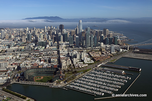
Aerial photograph of Oracle Park
San Francisco Giant's Stadium
toward Financial District and the Marin Headlands
Fog is moving in through the Golden Gate
San Francisco, California
Image ID: AHLE0364
© Herb Lingl/aerialarchives.com
Terms of Image Use |
Immediate License or Prints
Feedback
Aerial Photographs of San Francisco Architecture
Bay Bridge
Civic Center
Construction
Financial District
Fog
South Beach, China Basin and vicinity
Golden Gate Bridge
Historical
Hunter's Point
Marinas
Mission Bay
Nob Hill
Parks
Piers
Presidio
Residential Neighborhoods
San Francisco International Airport
Skylines
Skyscrapers and High Rise Office Towers
SoMa
Tenderloin
Tourist Attractions
Transbay
Treasure Island
Union Square
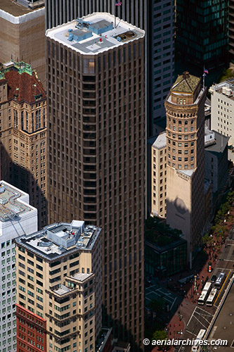
Aerial Photograph of the McKesson Plaza Tower
and the Hobart Building
Along Market Street
San Francisco, California
Image ID: AHLB4628
© Herb Lingl/aerialarchives.com
Terms of Image Use |
Immediate License or Prints
Feedback
Aerial Photographs of San Francisco Parks
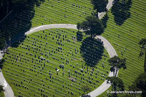
Aerial photograph of the National Cemetery
Presidio of San Francisco
Golden Gate National Recreation Area
San Francisco, California
Image ID: AHLB2193
© Herb Lingl/aerialarchives.com
Terms of Image Use |
Immediate License or Prints
Feedback
Aerial Photo Maps of San Francisco
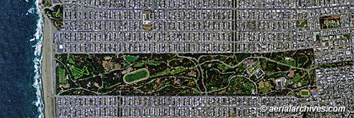
Aerial photo map of Golden Gate Park
and the Grid of Avenues and Streets
in the Richmond and Sunset districts
San Francisco, California
Image ID: AHLV3080
© aerialarchives.com
Terms of Image Use |
Immediate License or Prints
Feedback
Aerial Photographs of San Francisco Central Business District
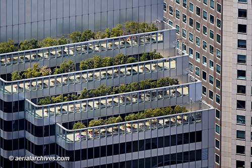
Aerial Photograph of Shaklee Terraces
Office High Rise
Rooftop Gardens and Balconies
One Front Street
San Francisco, California
Image ID: AHLB4965
© Herb Lingl/aerialarchives.com
Terms of Image Use |
Immediate License or Prints
Feedback
Aerial Photographs of San Francisco in the Fog
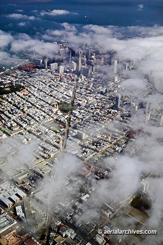
Aerial Photograph of Columbus Avenue
Through Patches of Fog
Down Columbus Avenue
Toward the Transamerica Pyramid
San Francisco, California
Image ID: AHLB3171
© Herb Lingl/aerialarchives.com
Terms of Image Use |
Immediate License or Print
Feedback