Aerial Photographs of San Francisco Bay Salt Ponds
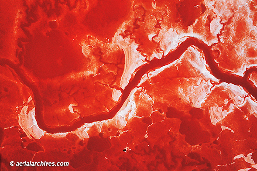
Image ID: AHLB2957
© Herb Lingl/aerialarchives.com
Aerial photographs show the vibrant colors of San Francisco Bay salt ponds better than any view from the ground.
The colors of the ponds range from bright reds, to green, yellow and brown. The colors depend primarily on the salinity of the pond.
The Ohlone were already producing salt in San Francisco Bay when Spanish explorers arrived.
Industrial production began in the 1850s. At that time, numerous small family operations created salt ponds from wetlands in Redwood City, Newark, Hayward and other portions of San Francisco Bay. Over the years, those small businesses were replaced by several companies. Eventually Cargill purchased these companies and built a network of salt ponds that covered over 16,000 acres.
In order to restore salt ponds back into wetlands, Cargill sold most of its San Francisco Bay salt pond holdings to the California Coastal Conservancy, the United States Fish and Wildlife Service, and private foundations in 2003. The project, known as the South Bay Salt Pond Restoration Project, is the largest wetland restoration project on the West Coast of the United States.
Aerial Archives’ collection of aerial photographs of San Francisco Bay salt ponds includes aerial overviews of the entire network of salt ponds and numerous detailed aerial views.
License this photograph or purchase a print
More aerial photographs of salt ponds
Details about salt pond aerial photography
Aerial photographs of wetlands
Aerial photographs of San Francisco Bay
