Aerial Photographs of Big Sur Landslides
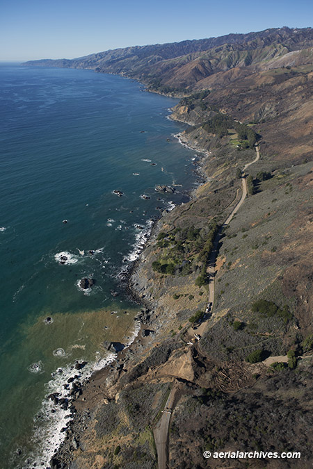
Image ID: AHLE0980
© Herb Lingl/aerialarchives.com
Aerial photographs of Big Sur landslides are invaluable in monitoring erosion along Highway One and in planning repairs.
Landslides have caused the collapse of portions of Highway One along Big Sur numerous times.
Highway One, officially known as California State Route 1, is a major north south highway most of which runs along the Pacific coastline. It’s the longest state highway in California and is over 650 long from its southern terminus near Dana Point in Orange County to its northern terminus near Leggett in Mendocino County.
Highway One was built in various pieces. The first section opened in the Big Sur area in the 1930s. Highway One in the Big Sur region covers a little over 70 miles from San Carpóforo Creek to Malpaso Creek.
Much of the highway winds along the cliffs of the Santa Lucia Mountains and passes over bridges. Notable Highway One bridges in the Big Sur region include the Bixby Creek Bridge, the Big Creek Bridge and the Rocky Creek Bridge.
Big Sur is a scenic, rugged and mountainous part of the California Central Coast where the Santa Lucia Mountains meet the Pacific Ocean. It is protected by the Big Sur Local Coastal Plan which was approved in the 1980s. The plan places extensive restrictions on development and population density. In addition, about 60% of the coastal region is owned by either private parties or government entities which prohibit development.
Before the construction of Highway One, Big Sur was one of the most remote parts of California.
Erosion and landslides affect various portions of Highway One along the California coast, but they are more frequent in the Big Sur area.
Highway One in the Big Sur area has been closed over 50 times because of land and mud slides.
Aerial photographs of these Big Sur landslides have been critical to highway repairs and erosion analysis.
License this photograph or purchase a print
More aerial photographs of Big Sur
More aerial photographs of Monterey County, California
