

Aerial Photographs of New Orleans, Louisiana
Aerial Photographs of New Orleans for Immediate Download
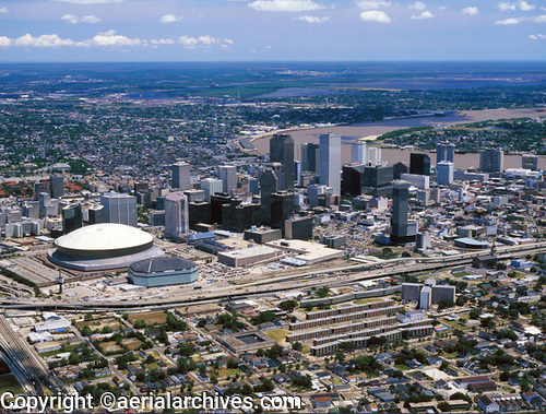
|
Aerial Archives library of aerial images contains a large collection of aerial photographs of New Orleans, Louisiana, including aerial photographs of downtown New Orleans, historic aerials of the delta, infrared aerial photographs and aerial maps of the delta and a large archive of current aerial photography of the New Orleans. Included is georeferenced aerial photography of the entire city of New Orleans. To review additional aerial photographs of New Orleans, please visit New Orleans stock aerial photography. The archive includes extensive aerial coverage of New Orleans with both oblique and vertical aerial photographs, including detailed views of wetland features, levees, specific islands in the delta, infrared sedimination and flow patterns and illustrative aerial images showing an overview of the delta. The library also contains an extensive collection of oblique aerial photographs of the New Orleans including the towns along the delta as well as agriculture, the Greater New Orleans bridges and bridges operated by the Port of New Orleans, commercial real estate, environmental subjects, wetlands, geographic features, and numerous additional categories. Specialized categories are also contained in the archive including an extensive collection of both oblique and vertical infrared aerial photographs of New Orleans. In addition aerial maps of the delta are available. The aerial photograph of the New Orleans, Louisiana Superdome shown on this page is available for immediate online license or prints or, to obtain it optimized to your needs please contact Aerial Archives directly and reference the ID number in the caption to the photograph. For specific requests for New Orleans aerial photos, delta aerial maps and aerial images of other portions of New Orleans, please use the pdf research request form. Additional information about obtaining stock aerial photography is also available at aerial photography research and at aerial photography research FAQs. |