

|
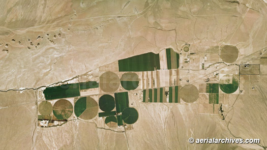
Aerial Archives maintains an extensive library of vertical photography of Inyo County, CA, including and historical and current aerial photography of Inyo county. Available imagery includes orthorectified aerial photography of Inyo County delivered both as prints and in digital form. Specialized services include delivery of geotiffs, customized labelling of aerial maps and output to specialized media. The aerial of coverage of aerial maps of Inyo County can also be completely customized both with respect to scale and to show an entire city, the complete county or only a set of blocks. Among the communities included in the collection are Big Pine, Bishop, Cartago, Darwin, Deep Springs, Dixon Lane-Meadow Creek, Furnace Creek, Homewood Canyon-Valley Wells, Independence, Keeler, Lone Pine, Mesa, Olancha, Pearsonville, Round Valley, Shoshone, Tecopa, West Bishop and Wilkerson. The aerial map of crop circles in Inyo County, California shown on this page is available for immediate online license or prints or, to obtain it optimized to your needs or as a higher resolution file please contact Aerial Archives directly and reference the ID number in the caption to the photograph. To request a custom flight to create an aerial map of Inyo or for current aerial map and aerial photography coverage of Inyo county, California please contact us.
|
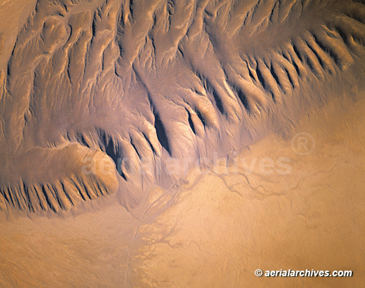
Aerial Photographs of Death Valley for Immediate Download
|
The aerial photograph of Death Valley National Park shown above is available for immediate online license or print, or
to obtain this image optimized to your specific specifications please contact Aerial Archives directly. For historical research of aerial photography of Inyo County, California we recommend that you use the research request form. Additional information about the process of researching historical aerial photography for your location is available at aerial photography research.
|