

Aerial Photographs and Satellite Imagery of Washington State
Aerial Photographs of Washington For Immediate Download
Aerial Archives provides vertical aerial photography and high resolution satellite imagery of all portions of the state of Washington, including both historical and current aerial photography and satellite imagery. High resolution satellite imagery is particularly useful when detailed imagery for remote areas of Washington is required. Available imagery includes georeferenced aerial photography of Washington. Specialized services include high resolution aerial photography and delivery of geotiffs, customized labelling of aerial maps and output to specialized media. The archive also includes oblique (at an angle) aerial photogrpahs of Bellingham, Everett, Olympia, the San Juan Islands, Seattle, the Port of Tacoma and the Washington State Pacific Coast. The coverage of aerial maps of the State of Washington can also be completely customized both with respect to scale and to show an entire city or metropolitan area or only a set of blocks, or if necessary, a vast portion of the state, or even a complete continuous view of the entire state.
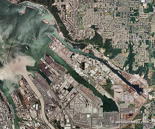
The aerial map of the Port of Tacoma showing sediment flowing into Commecement Bay and Pudget Sound from the Puyallup river in Washington shown above is available for immediate online license or prints, or to obtain this image optimized to your specification, please contact Aerial Archives directly.
|
|
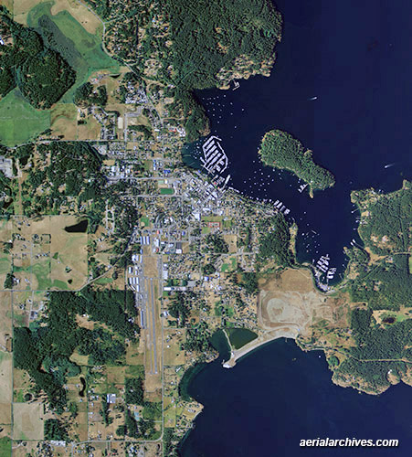
Aerial Archives also provides current and historical aerial maps of all of the San Juan islands in Washington. The aerial map of Friday Harbor, Washington shown above is available for immediate online license or prints or to obtain this image optimized to your specific specifications please contact Aerial Archives directly. Aerial Archives also delivers aerial maps and satellite imagery of the rest of the state of Washington as well as historical aerial maps of Washington.
|
|
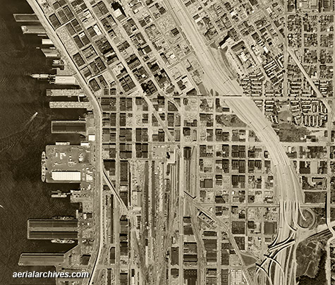
Historical aerial photographs of Washington State are available for numerous years. Recent aerial photography and satellite imagery is also available. For historical research of aerial photography and satellite imagery of Washington State, we recommend that you use the research request form. Additional information about the process of researching historical aerial photography and satellite imagery for your location is available at aerial photography research. The historical aerial photo of Seattle, Washington shown above is available for immediate online license or prints or to obtain this image optimized to your specific specifications please contact Aerial Archives directly.
|