|
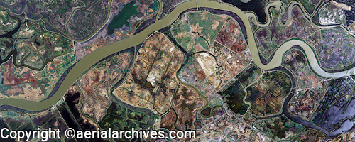
Aerial Archives library of aerial maps contains a large collection of vertical aerial map photography of the Sacramento River delta in California, including historic aerials of the delta, infrared aerial photographs and aerial maps of the delta and levees and a large archive of current aerial mapping photography of the Sacramento River delta. Included in this collection is georeferenced aerial photography of the entire Sacramento river delta for a number of years.">
The archive includes extensive aerial coverage of the Sacramento river delta with both oblique and vertical aerial photographs, including detailed views of wetland features, levees, specific islands in the delta, infrared sedimination and flow patterns and illustrative aerial images showing an overview of the delta.
The library also contains an extensive collection of oblique aerial photographs of the Sacramento river delta including the towns along the delta as well as bridges, commercial real estate, environmental subjects, wetlands, geographic features, airports, ports, harbors and marinas and numerous additional categories.
For specific requests for Sacramento River delta aerial photos, delta aerial maps and aerial images of other portions of the San Francisco Bay Area, please contact Aerial Archives research.
|