

Aerial Photographs of the Port of Oakland Available For Immediate Download
|
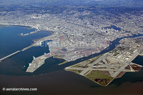
An large selection of aerial photographs of the Port of Oakland is contained in the library of Aerial Archives. This includes oblique aerials of the Port of Oakland including aerial photography of the infrastructure of the Port of Oakland. The collection includes dredging, barges, container loading areas, cranes, cargo ships and other vessels and numerous additional aerial photographs of the Port of Oakland. The aerial photograph of the the Port of Oakland and the former Alameda naval air station shown on this page is available for immediate online license or prints or, to obtain it optimized to your needs please contact Aerial Archives directly and reference the ID number in the caption to the photograph.Additional aerial photography of the Port of Oakland is available for immediate download or prints.
The archive also contains a comprehensive collection of vertical aerial photography of the Port of Oakland including aerial photos of the Port of Oakland area both in color and black and white. For specific requests for Port of Oakland aerial photos and other portions of the greater San Francisco Bay Area please contact Aerial Archives research. |