

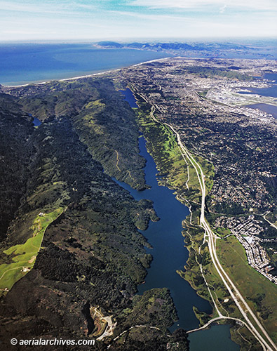
Aerial photograph of the San Andreas Fault
at the Crystal Springs Reservoir
San Mateo County, California
Aerial Photographs of the San Andreas Fault for Immediate Download
|
This aerial photograph of the San Andreas Fault at the Crystal Springs Reservoir shows interestate highway I-280, the city of San Francisco and the San Francisco International Airport with Point Reyes in the background. It is available for license for reproduction use on web
sites, in books, magazines, brochures and other printed, electronic and broadcast
media. It illustrates a portion of the San Andreas Fault running through San Mateo county, and then towards Point Reyes in the background. The aerial photograph of the San Andreas Fault at the Crystal Springs Reservoir shown above is available for immediate online license or prints or, to obtain it optimized to your needs please contact Aerial Archives directly and reference the ID number in the caption to the photograph. Many additional oblique aerial views of San Francisco are available from Aerial Archives as is a comprehensive selection of vertical aerial photography of San Mateo county and the San Francisco bay area. The collection includes both current and historical aerials many of which are not yet shown on this site. Also available are ground photographs of the Loma Prieta earthquake of 1989, including a unique selection of night time photographs of the earthquake damage in San Francisco. Please consult aerial photography research if you are seeking a specific aerial photograph not shown here.
|