

Aerial Photographs of Wetlands for Immediate Download
The Aerial Archives library contains one of the largest collections of aerial photographs of wetlands. To view aerial photographs of wetlands available for immediate online license or prints, please consult aerial photographs of wetlands.
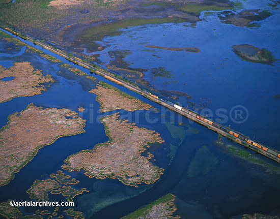
The archive contains extensive coverage of various wetland habitats from the air, and in depth coverage of numerous geographic areas including the San Francisco Bay Area, the Mississippi Delta, the Sacramento River Delta and Florida, California Central Valley, and Texas wetlands in Wharton county and the Galveston Bay region wetlands. Among the wetland habitats represented in this archive of wetland aerial photography are tidal marsh, agricultural wetlands, vernal pools, forrested wetlands, and wetlands restoration projects. The library includes both vertical and oblique aerial photographs of wetlands, historical wetland aerial photography, and infrared aerials of wetlands. Particularly in depth is the collection of aerial photographs of wetlands in San Francisco Bay. This includes aerial photography of Albany Bulb Lagoon, Albany Salt Marsh, California Bair Island, Bel Marin Keys, Berkeley Meadows, Burlingame Lagoon , Charleston Slough, Cogswell Marsh, Cooley Landing, Corte Madera Ecological Reserve, Coyote Creek Lagoon Crissy Field, Cullinan Ranch, East San Rafael Wetlands, Edgerley Island Marina, Emeryville Crescent, Gallinas Creek, Hamilton Airfield, Hayward Marsh Huichica Creek, KGO Towers, Mare Island Refuge Martin Luther King, Jr. Marsh Montezuma Wetlands, Mountain View Tidal Marsh, Muzzi Marsh, Napa River Flood Control, Napa-Sonoma Salt Ponds, Northern Outer Bair Island, Novato Creek, Pacific Shores Deep Water Slough, Palo Alto harbor, Petaluma Marsh, Pier 94, Pier 98, Point Buckler, Port Sonoma Marina, Redwood High School Marsh, Richardson Bay Bridge Marshes, Roberts Landing Shoreline Marshlands, Rush Creek - Cemetery Marsh, Ryer Island, Schellville, Sonoma Baylands, South Basin Wetlands, South Bay Salt Pond Project, Sunnyvale Baylands Park, Tolay Creek, Tubbs Island, Viansa Winery, and Whales Tail marsh. The aerial photograph of the a train crossing the wetlands in the Mississippi River delta shown above is available for immediate online license or prints or, to obtain it optimized to your needs please contact Aerial Archives directly and reference the ID number in the caption to the photograph.
To request specific wetland aerial photography please contact contact us. |