

Historical Stock Aerial Photography of Oakland, CA
Historical Aerial Photography Of Oakland For Immediate Download
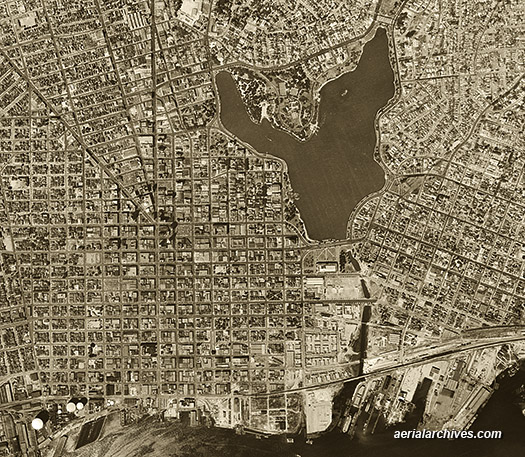
| An extensive selection of historical vertical and oblique stock aerial photographs of Oakland, California is available from Aerial Archives. This includes detailed historical aerial maps of Oakland including aerial views of downtown Oakland, Frank Ozawa park, the Oakland airport, the Oakland estuary, the Oakland harbor, the Oakland hills, and the major bridges, freeways, buildings and geographic features.
Also available are numerous oblique stock aerial photographs of Oakland including Jack London Square, Lake Merritt, Oakland coliseum, the Port of Oakland, overviews of the Port of Oakland, the Oakland zoo and the Tribune Tower. Also included are numerous aerial photographs of the freeway corridors of interstate 880, I-880, interstate 980, I-980, interstate 580, I-580 and highway 24, aerial photographs of the major freeway and highway interchanges, and a number of aerial views from Oakland toward San Francisco. Historical Oakland aerial photography available for immediate download is available at historical aerial photography of Oakland. The aerial photograph of Oakland in 1946 shown above is available for immediate online license or prints, or to obtain this image optimized to your specification, please contact Aerial Archives directly.
|
|
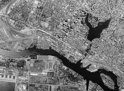
The aerial photograph of Oakland in 1998 shown above is available for immediate online license or prints, or to obtain this image optimized to your specification, please contact Aerial Archives directly. For historical aerial photography of Oakland, California, we recommend that you use the pdf research request form. Additional information about obtaining stock aerial photography is also available at aerial photography research and at aerial photography research FAQs.
|