

Aerial Photographs of San Francisco Bay
Custom Assignments and Existing Image Library
San Francisco Bay Aerials For Immediate Download
|
Aerial Archives creates custom aerial photography and videography of San Francisco bay and maintains an extensive collection of both current and historical aerial photography of the San Francisco bay area. To view aerial photographs of San Francisco Bay available for immediate online license or prints, please consult aerial photographs of San Francisco bay.
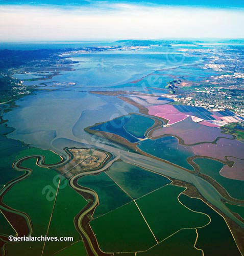
This collection includes comprehensive current and historical oblique aerial photography of San Francisco Bay including aerial photographs of the bay area's geographic and geological features, including salt ponds, varying habitats and microclimates, rivers and creeks, lakes, parks, wetlands, fault lines, tide lines, shorelines, islands and similar features. In addition, the archive contains comprehensive collection of vertical San Francisco Bay aerial photography including aerial photographs of San Francisco Bay both in color, infrared and black and white. For additional information about vertical aerial photography available for the San Francisco Bay area, please consult Aerial Maps of San Francisco Bay. For aerial photographs of the city of San Francisco, please consult aerial photographs of San Francisco. The aerial photograph of the overview of San Francisco Bay from Alviso to the northwest is available for immediate online license or prints, or to obtain this image optimized to your specific specifications please contact Aerial Archives directly.
|
Aerial Photographs of the Parks of San Francisco Bay
|
Among the aerial photographs of San Francisco bay area parks included in the collection are the
Golden Gate National Recreation Area,
Presidio,
Golden Gate park and
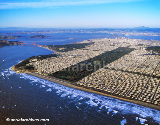
the East Bay Regional Parks. The aerial photograph of Golden Gate Park and Ocean Beach with the skyline of the city of San Francisco and San Francisco Bay in the background shown above is available for immediate online license or prints, or to obtain this photograph optimized to your specific specifications please contact Aerial Archives directly. |
|
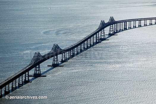
Among the aerial photographs of San Francisco bay area bridges included in the collection are
the San Francisco Oakland Bay bridge,
the Benicia bridge,
the Carquinez bridge,
the Dumbarton bridge,
the Golden Gate bridge,
the Richmond San Rafael bridge and
the San Mateo bridge. The aerial photograph shown above of the Richmond San Rafael bridge which is the northern most bridge spanning San Francisco Bay is available for immediate online license or printsor, to obtain it optimized to your needs please contact Aerial Archives directly and reference the ID number in the caption to the photograph.
|
|
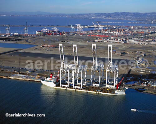
Among the ports of San Francisco bay included in the collection are
the Port of Oakland,
the Port of Richmond,
the Port of San Francisco, and
many of the marinas, and commercial docking areas in San Francisco. The aerial photograph of the Port of Oakland in San Francisco Bay shown above is available for immediate online license or prints, or to obtain this photograph optimized to your specific specifications please contact Aerial Archives directly.
|
|
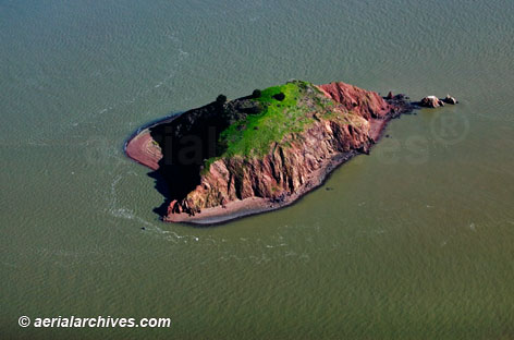
Among the aerial photographs of San Francisco bay islands included in the collection are aerial photographs of
Alcatraz island,
Alameda island,
Angel island,
Bair island,
Belvedere,
Coast Guard island,
Greco island,
the Marin islands,
Yerba Buena island and
Treasure island, as well as many of the rocks protruding from the Bay (e.g. Red Rock, the Brothers and the Sisters). For aerial photography of Alctraz island, please consult Aerial Photographs of Alcatraz Island. The aerial photograph of Red Rock in San Francisco Bay shown above is available for immediate online license or prints, or to obtain this photograph optimized to your specific specifications please contact Aerial Archives directly.
|
|
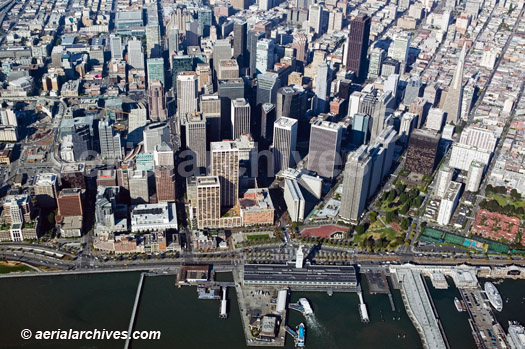
The San Francisco Bay areas cities included in the archive include
Oakland,
Palo Alto,
San Francisco and
San Jose. This collection of aerial photographs also includes current and historical aerial views of the other municipalities that are part of the San Francisco Bay area. The aerial photograph of the city of San Francisco viewed from San Francisco Bay shown above is available for immediate online license or prints, or to obtain this photograph optimized to your specific specifications please contact Aerial Archives directly. |
|
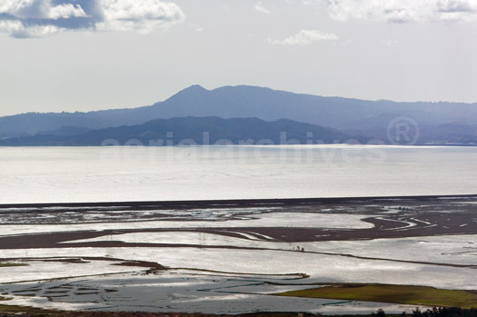
The collection includes perspectives of each portion of San Francisco bay as well as comprehensive vertical and oblique aerial photographs of the entire periphery of San Francisco bay and its surrounding geography. The aerial photograph of the northern portion of San Francisco Bay with Mount Tamalpais in the background shown above is available for immediate online license or prints, or to obtain this photograph optimized to your specific specifications please contact Aerial Archives directly.
|
|
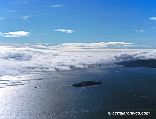
The archive also contains a unique collection of aerial photographs of fog in San Francisco bay. This includes large collections of aerial photographs of
fog at the Golden Gate bridge, aerial photographs of fog rolling over the Marin headlands into San Francisco bay, and aerial photographs of fog creating a number of unusual effects in the bay area. A number of other weather phenomena in the bay area are also documented from the air. The aerial photograph of fog rolling into San Francisco Bay shown above is available for immediate online license or prints, or to obtain this photograph optimized to your specific specifications please contact Aerial Archives directly.
|
|
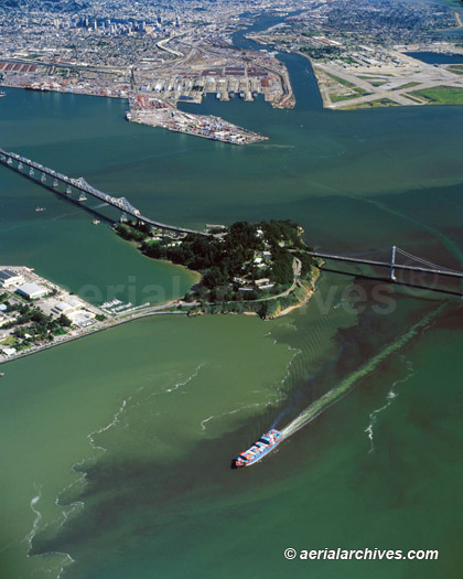
The aerial photograph of the a containership leaving the Port of Oakland, which just passed under the Bay Bridge passing through a phytoplancton bloom (red tide) in
San Francisco Bay shown above is available for immediate online license or prints, or to obtain this photograph
optimized to your specific specifications please contact Aerial Archives directly. Many additional aerial photographs of San Francisco bay's tidal patterns are available from the Aerial Archives library. The archive also contains aerial photography of each of the bridges crossing San Francisco Bay, the cities adjacent to San Francisco bay and each of the marinas, ports, parks, harbors and airports located in the San Francisco Bay Area. To obtain an aerial photograph of San Francisco not shown on this site, please contact Aerial Archives directly. For historical aerial photography of San Francisco Bay we recommend that you use the research request form.Additional information about obtaining existing aerial photography of San Francisco Bay is also available at aerial photography research and at aerial photography research FAQs. |