|
Aerial Archives provides historical and current aerial photography and high resolution satellite imagery for the entire United States. Imagery is usually delivered as high resolution digital files via the internet.
For historical research of aerial photography we recommend that you use the pdf research request form. Additional information about the process of researching historical aerial photography for your location is available at aerial
photography research
and at
aerial photography research FAQs
To browse aerial historical aerial photography immediately available online as prints or licenses, please visit:
California Historical Aerial Photography
Los Angeles Historical Aerial Photography
San Francisco Historical Aerial Photography
Historical Aerial Photography of Chicago
Historical Aerial Photography of Cleveland
Historical Aerial Photography of Fresno
Historical Aerial Photography of Las Vegas
Historical Aerial Photography of Massachusetts
Historical Aerial Photography of Miami
Historical Aerial Photography of Nashville
Historical Aerial Photography of New Jersey
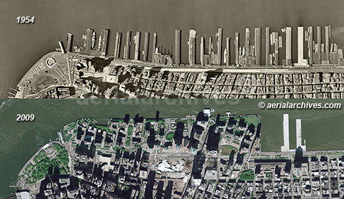
Historical Aerial Photography of New York
Historical Aerial Photography of Rhode Island
Historical Aerial Photography of San Diego
Historical Aerial Photography of Washington, DC
|