Herb Lingl

Malibu Hills Wildflower Bloom after the Woolsey Fire
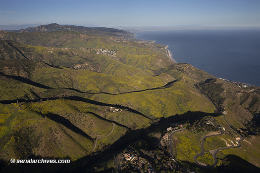
Malibu Hills, wildflower bloom, spring, Woolsey Fire aftermath, AHLE0391
This aerial photograph of the Malibu Hills in Los Angeles County, California shows the wildflower bloom during the spring of 2019.
Image ID: AHLE0391
© Herb Lingl/aerialarchives.com

This was the first spring after the Woolsey wildfire passed through the area. The fire and subsequent winter rains caused an exceptionally intense bloom. Many of the flowers were the yellow black mustard plant, which quickly established itself after the fire and presents a challenge to some native plants.

The Woolsey Fire burned over 96,000 acres in Los Angeles and Ventura County from November 8-21, 2018. It caused 3 fatalities and destroyed 1,643 structures including houses owned by Neil Young and Kim Bassinger.

The fire started on the Santa Susana Field Laboratory property, which is a complex of industrial research and development facilities that is owned by Boeing. It is located in the Santa Susana Mountains above the Simi Valley.

Hundreds of homes in Malibu were destroyed on both sides of the Pacific Coast Highway. One home in the Malibu Hills which burned to the foundation is visible in the foreground of this aerial photograph adjacent to two homes which survived. In the far distance, downtown Los Angeles is visible through a thin layer of haze.

The Aerial Archives library contains numerous additional aerial photographs of the aftermath of the Woolsey Fire and the Malibu Hills wildflower bloom the following spring.

License this photograph or purchase a print.

More aerial photography of California wildfires and their aftermath.

More aerial photography of Los Angeles County, California.

Additional information about the collection Los Angeles County aerial photography.

Share

Lampson Field airport, Lakeport, CA aerial photography

aerial photograph of Lampson Field airport, Lakeport, Lake County, California
This aerial photograph of Lampson Field airport, Lakeport, Lake County, California is part of an extensive collection of current and historical aerial photographs of Lampson Field, Lakeport, California and Lake County available from Aerial Archives. This aerial photograph shows a view of Lampson Field airport (102) toward the city of Lakeport and Clear Lake during the winter. North of Lakeport in the background are the mountains of the Mendocino National Forest, including, in the center background, Snow Mountain, part of the Snow Mountain Wilderness. The summit of East Snow Mountain has an elevation of 7056′, the highest elevation in Lake County. Lampson Field is a public airport owned and operated by Lake County, located 3 miles south of the town of Lakeport. The airport covers 68 acres, has one runway (28/10), features a 4 degree glide path 2 light, precision approach path indicator lighting system (PAPI), an automated weather observing system (AWOS) and a pilot controlled lighting system. The field elevation is 1380′ (420.7 meters). The runway is asphalt, 3600′ long and 60′ wide. The CTAF/UNICOM frequency is 122.8, and AWOS-3 is available on 118.35 or by dialing 707.262.0380. As of the year ending December 31, 2017, the airport had an average of 209 operations per day. Among the businesses on the field are Tom’s Aircraft Enterprises, which provides aircraft repair and maintenance services and annual inspections, Steve’s Aircraft Repair, which specializes in major aircraft structural repair and LASAR, an aircraft repair shop that specializes in Mooney aircraft and is a Mooney parts dealer. REACH Air Medical Services has a operational base at the airport and bases a helicopter at the field. 100LL fuel is available via a self serve fuel island. A published RNAV (GPS) instrument approach is available for Lampson Field. Lampson Field was opened as a public airport in 1941.
Image ID: AHLE0379
© Herb Lingl/aerialarchives.com

License this photograph or purchase a print.

More aerial photography of Lampson Field airport.

More aerial photography of Lake County, California.

Share

San Francisco Skyline Aerial Photo from Giants Stadium

aerial photograph San Francisco Giants stadium financial district skyline
This aerial photograph the San Francisco financial district skyline shows the Giants Stadium and South Beach Marina in the foreground. Currently known as Oracle Park, the stadium has been renamed numerous times. During its opening in 2001 it was called Pacific Bell Park, then, in 2003, SBC Park and in 2006 AT&T Park. To the right of the stadium is the South Beach Harbor Marina. Visible in this aerial photograph of the San Francisco skyline are many of San Francisco’s high rises including the Salesforce Tower which was completed in 2018, The Transamerica Pyramid, 555 California (the Bank of America Tower), 345 California Center, One Rincon Hill, the Spear Street towers and numerous other high rises. In the background a layer of fog is moving in through the Golden Gate, and behind it the Marin Headlands. Alcatraz island is visible under the fog to the right of the Salesforce Tower.
Image ID: AHLE0364
© Herb Lingl/aerialarchives.com

License this photograph or purchase a print.

More aerial photography of San Francisco skylines.

Detailed aerial photographs of San Francisco skyscrapers.

Share

Levi’s Stadium

aerial photograph Levi's Stadium Santa Clara, California
This aerial view of Levi's Stadium in Santa Clara, California, home of the San Francisco 49ers, shows elements of the stadium design that made it the first new construction professional football stadium that received a Gold LEEDS certification. These include a green roof of approximately 27,000 square feet and approximately 20,000 square feet of rooftop solar panels. The stadium uses recycled water where possible. During construction a large portion of construction waste was recycled or salvaged.
Image ID: AHLE0249
© Herb Lingl/aerialarchives.com
Share

Boating on the Petaluma River

Power Boat Aerial Petaluma River
A power boat creates a long wake on the Petaluma River, Sonoma county, California. Adjacent to the Petaluma River in this aerial photograph is the Petaluma Marsh Wildlife Area, which totals 4,200 acres of tidal salt marsh, mudflats, coastal oak woodlands, and coastal scrub habitats. The habitats support numerous species including willits, curlews, dowitchers, night herons, and black-bellied plovers, migratory birds and deer, raccoons, jackrabbits, and foxes. The wetland in the wildlife area is the largest remaining natural tidal brackish marsh in California.
Image ID: AHLE0242
© Herb Lingl/aerialarchives.com

License this photograph or purchase a print.

More aerial photography of Sonoma County, California.

More aerial photography of Petaluma, California.

Share

Apple Park

Apple Park, Cupertino, California
This aerial photograph shows Apple Park, Apple's new corporate headquarters, as it nears completion. 2000 people already work in the building. When completed Apple Park will be one of the largest and most energy efficient buildings in the world.
Image ID: AHLE0229
© Herb Lingl/aerialarchives.com

License this photograph or purchase a print.

More aerial photography of Cupertino.

More aerial photography of Silicon Valley.

Share

San Francisco From the Marin Headlands

The fog rolls in from the Pacific Ocean in this view of San Francisco from the Marin Headlands. One tower of the Golden Gate bridge is visible in the upper center of the photograph. Much of the San Francisco financial district is obscured by fog, but the Salesforce Tower under construction and the Bank of America Tower rise above the fog. Alcatrax, Yerba Buena Island, the Port of Oakland and the Oakland Hills are in the background.
Image ID: AHLE0192
© Herb Lingl/aerialarchives.com

License this photograph or purchase a print.

More aerial photography of San Francisco in the fog.

More aerial photography of Marin County, California.

Share