Flying Presentations At Aerial Archives (T-6 and T-33)

Pilots Pat Belanger and Will Whiteside
Pilots Patrick Belanger and Will Whiteside exchange information after making presentations about flying the North American T-6 and the Lockheed T-33 at Visions From Above, an exhibit of aerial photography and fund raiser for the Western Horizon Flying Museum and the Petaluma Arts Center, sponsored by Aerial Archives, Lagunitas Brewing Company, the Professional Aerial Photographers Association International, Warren Percell Studios, with additional participation by numerous additional aviation related businesses.
Image ID: AHLC3345
© Herb Lingl/aerialarchives.com

Western Horizon Flying Museum
Airport Muse

Share

Aerial Archives Hosts Western Horizon Flying Museum Presentations

Top Cub--J-3 Cub
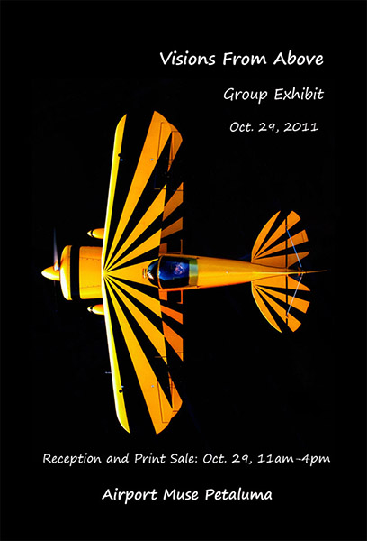
Aerial Archives hosts presentations at its Petaluma Airport offices Saturday, Oct. 29 about flying and maintaining historical aircraft for Visions From Above, a reception and print sale and series of presentations that is raising funds for the Western Horizon Flying Museum, dedicated to keeping historical aircraft flying. Presentations begin at 1:00pm with Pat Bellanger speaking about flying the Lockheed T-33 Shooting Star. At 1:30pm Will Whiteside of Team SteadFast air racing with speak about flying the North American, T-6, Texan. At 2:00pm brother and sister team Julie Belanger and Bruce Perlich will give a presentation entitled Whatever Happened to the Flying Lady Restaurant?, about the famous aviation themed restaurant and private aviation museum founded by their parents. Ann Elsbach, founder of the West Valley Flying Club, one of the largest flying clubs in the world, who now specializes in tailwheel flight training, will speak about Flying the Loveable, Squirrelly Luscombe. Herb Lingl, Aerial Archives director and Airport Muse curator, will speak about flying the Antonov, AN-2, the world's largest biplane and at 3:00pm, Aeroventure mechanic and pilot, Joe Davis, will speak about Maintaining Historical Aircraft: An Aviation Mechanic's Perspective. Joe was a mechanic for United Airlines for over 25 years, is a pilot and now specializes in maintaining historical aircraft. Visions From Above also features a silent auction of aerial photography prints from leading photographers from around the world, a portion of which benefit the Western Horizon Flying Museum. The stunning photograph of the Piper J-3 Cub, two seat aircraft, which were manufactured from 1938 through 1947, was created by Stan Macbean of Utah by Air, and is one of the prints part of the Visions From Above exhibit.
Top Cub
Image ID: AHLM3021
© Stan Macbean/utahbyair.com

Western Horizon Flying Museum
Airport Muse

Share

Aerial Archives Sponsors Visions From Above Exhibit

Visions From Above Exhibit | Oct 29 | Petaluma Airport
Aerial Archives sponsors Visions From Above, a reception and print sale of the work of leading aerial photographers at the Petaluma Airport on Saturday, October 29 from 11am-4pm. Proceeds from the sale of prints benefit the Western Horizon Flying Museum, dedicated to keeping historical aircraft flying. The Lagunitas Brewing Company is also a sponsor of the event and will be providing a keg of its famous India Pale Ale. Numerous aviation and northern California businesses are donating prizes to the raffle which benefits the flying museum and the Petaluma Arts Center. The event takes place at the Aerial Archives offices at the Petaluma Airport, located in the main airport office building at 561 Sky Ranch Rd, Suite E, Petaluma, CA. Additional information is available on the web site of Airport Muse, the event organizer and on the Airport Muse Facebook page.

Airport Muse
Airport Muse on Facebook

Share

Aerial Photography South of Market SoMa San Francisco


Aerial photograph SFMOMA Museum of Modern Art SoMaSouth of Market San Francisco
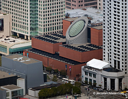
The San Francisco Museum of Modern Art (SFMOMA), designed by architect Mario Botta is in the center of this aerial photograph of San Francisco's South of Market Street (SoMa) district. To the right of the SFMOMA at 181 Third Street is the W San Francisco, a luxury boutique 33 story high rise hotel. In the foreground are the buildings of Yerba Buena Gardens that front Third Street. To the left of the San Francisco Museum of Art in this aerial photograph is the St. Regis Museum Tower, a five star hotel designed by Skidmore, Owings, and Merrill which includes 102 luxury condominiums and 269 hotel rooms.
Image ID: AHLB8084
San Francisco, California
© Herb Lingl/aerialarchives.com

More aerial photography of San Francisco
More aerial photography of San Francisco’s SoMa District
Share

Aerial Photography San Francisco | Fog


Aerial Photography San Francisco Toward Transamerica Fog
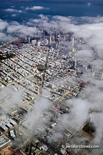
Fog rolling in over San Francisco ensures constantly and rapidly changing aerial views of the city. This aerial photograph shows the patches of fog at the leading edge of the bank moving in over San Francisco in the early afternoon. Some patches of fog already obscure parts of North Beach and much of San Francisco's financial district, though Coit Tower and some of the Embarcadero and Transamerica pyramid are still visible in this aerial perspective looking down Columbus Avenue.
Image ID: AHLB3171
San Francisco, California
© Herb Lingl/aerialarchives.com

More aerial photography of San Francisco
More aerial photography of San Francisco in the fog
Share

Historical Aerial Photography: Then and Now Comparisons | Manhattan

Historical Aerial Photography Comparison New York City 1954 2009
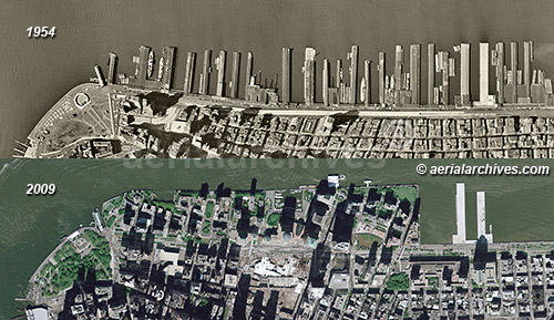
The Hudson river shoreline of Manhattan changed dramatically during the last five decades. The two historical aerial photographs illustrate the amount of change that has occurred at this portion of Manhattan between 1954 and 2009. As the 1954 historical aerial photograph shows, the piers along the Hudson river were still actively used at that time. Eventually, shipping activity shifted to the New Jersey side of the Hudson river. In 1973 what were once Piers 1 through 21 were buried under landfill from the World Trade Center construction project and became Battery Park City. The ongoing construction of the new World Trade Center buildings ensures that this portion of Manhattan will continue to change significantly in the near term.
Manhattan, New York City
1954-2009
Image ID: AHLV3409

More historical aerial photography then and now comparisons.
Share

Historical Aerial Photography of Las Vegas

Historical Aerial Photography Las Vegas 1973 and 2010
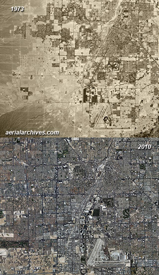
These two historical aerial photographs show how much Las Vegas, Nevada has changed during several decades of very rapid growth, multiplying its size several fold during those years. The historical aerial photograph on the top was acquired in 1973 and the aerial on the bottom is a mosaic of photographs acquired in 2010. The city has expanded into the adjacent desert with particularly strong growth in the western portion of the city. High resolution aerial photography of sections of the city also show on a more detailed scale how rapidly certain portions of Las Vegas have changed during very short periods of time. Particularly dramatic are the changes during the 1990s in the northwestern portion of the city.
Las Vegas, Clark County, Nevada
1973-2010
Image ID: AHLV3391

More historical aerial photography of Las Vegas.

Share

Aerial Photography of Geothermal Power Plants

Aerial photography steam Geysers geothermal power plants
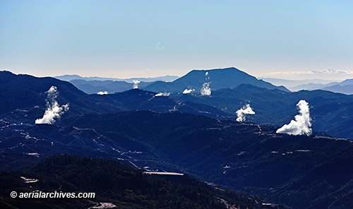
Steam rises from numerous geothermal power plants which are part of the Geysers complex, the largest geothermal complex in the world. Twenty two geothermal power plants draw steam from more than 350 wells. Seismic and gravity studies indicate that the source of the heat for the geothermal power plants is a magma chamber over 8 miles in diameter and 4 miles underground. Calpine Corporation owns and operates 19 of the active geothermal power plants. Electrical production from the Geysers geothermal power plants peaked in 1987 and has declined since then as the underground water source gradually declines. Research and development of new geothermal power technologies called enhanced geothermal systems do not require convective hydrothermal resources and are expected to increase power output from the Geysers geothermal complex in the future.
Mayacamas Mountains
Lake and Sonoma Counties, California
Image ID: AHLB8018
© Herb Lingl/aerialarchives.com

More aerial photography of geothermal power plants.

Share

High Resolution Satellite Imagery of China

Satellite Imagery Ningbo China
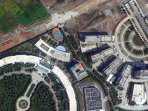
This high resolution satellite image documents the edge of development in Ningbo, one of China's oldest cities. While it has an ancient history, Ningbo's economy is growing rapidly. High resolution satellite imagery is proving to be an exceptionally useful tool in China, because of its vast size, the rapid changes taking place and the more limited availability of airborne imaging. Atmospheric visibility issues can further stretch out the time frames for projects relying on acquiring new imagery. That's why an archive of existing, high resolution, cloud free, recent satellite imagery of China can be invaluable. Aerial Archives provides its US clients access to DigitalGlobe's large archive of high resolution satellite imagery of China which includes recent imagery of over 150 of China's largest cities.
Ningbo, Zhejiang, China
Image ID: AHLS2010

More about high resolution satellite imagery of China
Share

Aerial Photography of San Francisco Architecture


Aerial Photography San Francisco Architecture | buildings with numerous different architectural styles
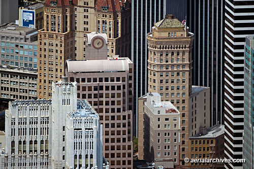
Many different styles of San Francisco architecture are shown in this aerial photograph of a portion of the financial district. At the left in the foreground is 140 New Montgomery Street, San Francisco's first skyscraper. Built in the art deco architectural style, 140 New Montgomery served as an office building for over 80 years until it was converted into residential condominiums. Directly behind 140 New Montgomery is 33 New Montgomery Street, a 20 story high rise office building designed in the post-modern architectural style. The building wraps around the Bank of America Building at 623 Market Street, which is not as tall and not visible in this aerial photograph. Prominent features of 33 New Montgomery Street are the large clock tower and spike at the top of the building. Directly behind 33 New Montgomery Street is the Hunter-Dulin Building, located at 111 Sutter Street. Built in a Renaissance revival architectural style, this 308 foot high rise is San Francisco's only building with Romanesque and French Chateau ornamentation. Directly to the right of 33 New Montgomery Street in this aerial photograph is the Hobart Building designed by John Willis, San Francisco's leading architect during the rebuilding of San Francisco after the 1906 earthquake and fire. Designed in the beaux-arts classical revival architectural style with Renaissance/Baroque ornamentation, the building was completed in less than one year. Serving as a background to the Hobart building is 44 Montgomery Street, a modernist 43 floor high rise designed by architects John Graham and Associates. To the right of 44 Montgomery Street is 595 Market Street, another skyscraper designed in the modernist architectural style by Skidmore, Owings and Merrill. Just a very small portion of the post modern style KPMG Building, 55 Second Street, is visible on the far right portion of the frame of this aerial photograph.
San Francisco
Image ID: AHLB5490
© Herb Lingl/aerialarchives.com

More aerial photography of San Francisco architecture
More aerial photography of San Francisco’s financial district
Search aerial photography of San Francisco architecture

Share